Mesoscale Discussion 0634
NWS Storm Prediction Center Norman OK
0113 PM CDT Tue May 03 2022
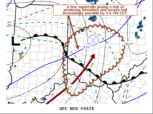
Areas affected...Parts of western into central Ohio and adjacent
portions of the Ohio Valley
Concerning...Severe potential...Watch likely
Valid 031813Z - 032000Z
CORRECTED TIME FROM UTC TO DAYLIGHT TIME IN SUMMARY
Probability of Watch Issuance...80 percent
SUMMARY...A few supercells may gradually develop across parts of the
middle into upper Ohio Valley through late afternoon. Some of these
may pose a risk of producing tornadoes, in addition to large hail,
including around the Dayton OH area as early as 5-6 PM EDT.
DISCUSSION...A southwesterly lower/mid tropospheric speed maximum,
and associated cyclonic vorticity center to its northwest, are in
the process of migrating north-northeast of the Ohio River, toward
the upper Ohio Valley/lower Great Lakes region. While the boundary
layer across much of Ohio into the upper Ohio Valley is generally
cool and stable, destabilization is ongoing along and northeast of
a warm frontal zone across southwestern Ohio, in the immediate wake
of the initial perturbation.
With the primary upstream mid-level short wave trough turning east
of the middle Mississippi Valley, the warm sector of an associated
surface cyclone appears likely to continue to attempt to spread
northeastward across Ohio. Through 21-22Z, it appears that the warm
frontal zone may become a focus for increasing boundary-layer
destabilization and intensifying thunderstorm development near the
Dayton OH area. This is where latest Rapid Refresh forecast
soundings suggest that at least some backing and strengthening of
flow around 850 mb may contribute to enlarging clockwise curved
hodographs. It appears that the environment may become conducive to
supercells with the potential to produce tornadoes, in addition to
severe hail, with a tendency to gradually develop east-northeastward
into early evening.
..Kerr/Smith.. 05/03/2022
...Please see www.spc.noaa.gov for graphic product...
ATTN...WFO...PBZ...RLX...CLE...ILN...LMK...IWX...IND...
LAT...LON 40188484 40918347 40468213 39638225 38998340 38368461
40188484
|


 @NWSSPC