Mesoscale Discussion 0711
NWS Storm Prediction Center Norman OK
0517 PM CDT Tue May 10 2022
Areas affected...TX South Plains into the TX/OK Panhandles
Concerning...Severe Thunderstorm Watch 198...199...
Valid 102217Z - 110015Z
The severe weather threat for Severe Thunderstorm Watch 198, 199
continues.
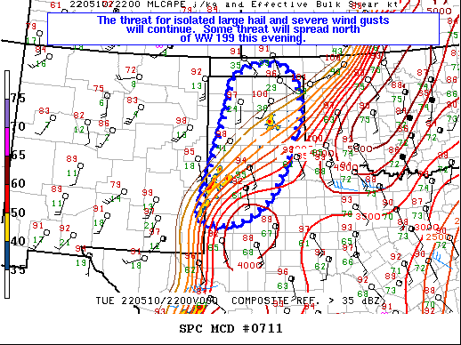
SUMMARY...The threat for isolated large hail and severe wind gusts
will continue into the early evening, and potentially spread north
of WW 199. A somewhat more widespread severe wind threat may evolve
with time a little later this evening.
DISCUSSION...At 22Z, one cluster of vigorous convection is ongoing
west of Lubbock, where multiple severe wind gusts have recently been
noted on the TX Mesonet. This activity is ongoing along the northern
edge of returning low-level moisture, with steep low/midlevel lapse
rates supporting MLCAPE in the 1500-2500 J/kg range. Deep-layer
shear is relatively weak, with the KLBB VWP depicting modest
unidirectional southerly flow through a deep layer. This environment
will support an isolated hail threat with the strongest updrafts,
though the more prevalent risk will likely be severe wind gusts, as
outflows consolidate and small clusters move northward parallel to
the deep-layer flow.
Further north, another storm cluster has developed east of Amarillo,
within a similar environment, though moisture return is slightly
slower in this region compared to areas further southwest. With
time, an increasing severe wind and isolated hail risk may spread
north of WW 199, potentially as far as the OK Panhandle. Watch
extension or a small new watch may be needed north of WW 199.
..Dean/Thompson.. 05/10/2022
...Please see www.spc.noaa.gov for graphic product...
ATTN...WFO...LUB...AMA...MAF...ABQ...
LAT...LON 32980327 35520245 36500219 36790159 36780068 36340027
35570013 34290059 33380111 32840184 32740247 32770305
32980327
|


 @NWSSPC