|
| Mesoscale Discussion 718 |
|
< Previous MD Next MD >
|
|
Mesoscale Discussion 0718
NWS Storm Prediction Center Norman OK
0632 AM CDT Wed May 11 2022
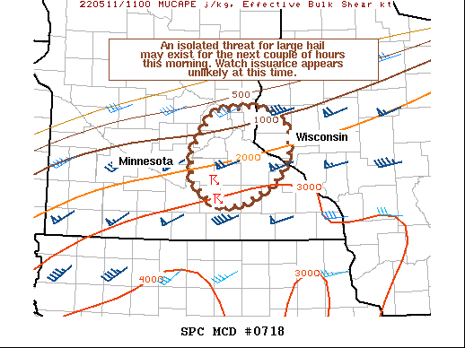
Areas affected...Portions of southern/east-central MN into far
western WI
Concerning...Severe potential...Watch unlikely
Valid 111132Z - 111300Z
Probability of Watch Issuance...20 percent
SUMMARY...An isolated threat for large hail may exist for the next
couple of hours this morning. Watch issuance appears unlikely at
this time.
DISCUSSION...An elevated supercell has recently developed and split
over south-central MN. The left split, which is moving northward
towards the Twin Cities, has strengthened and become dominant.
Although large-scale forcing remains weak over southern MN, there
are steepened mid-level lapse rates present over this region per the
))Z MPX sounding and latest mesoanalysis estimates. Around 1500-2500
J/kg of MUCAPE and strong (50+ kt) of deep-layer shear will likely
support continued organization and intensity for the left-split
supercell for the next couple of hours. Isolated large hail will be
the main threat with this supercell as it approaches the Twin Cities
metro through 13Z. At this point, the overall severe threat should
remain fairly isolated, as it does not appear that additional
convection will form due to weak forcing. Watch issuance currently
appears unlikely, but convective trends with this supercell will be
closely monitored.
..Gleason/Edwards.. 05/11/2022
...Please see www.spc.noaa.gov for graphic product...
ATTN...WFO...ARX...MPX...
LAT...LON 43969351 44249388 44629390 45129353 45199275 44949220
44549221 44229247 43949305 43969351
|
|
Top/All Mesoscale Discussions/Forecast Products/Home
|
|


 @NWSSPC