|
| Mesoscale Discussion 747 |
|
< Previous MD Next MD >
|
|
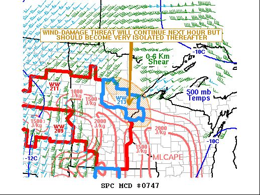
   Mesoscale Discussion 0747
   NWS Storm Prediction Center Norman OK
   0840 PM CDT Thu May 12 2022

   Areas affected...Eastern Minnesota...Far Northwest Wisconsin

   Concerning...Severe Thunderstorm Watch 213...

   Valid 130140Z - 130315Z

   The severe weather threat for Severe Thunderstorm Watch 213
   continues.

   SUMMARY...A wind-damage threat will continue for another hour or so
   across parts of eastern Minnesota, and may impact far northwestern
   Wisconsin. But the threat should become more isolated with time. A
   local extension could be necessary just to the east of WW 213.

   DISCUSSION...A large-scale bowing line segment is currently ongoing
   in east-central Minnesota. Wind-damage will continue to be possible
   along the leading edge of the line as it moves eastward to the edge
   of WW 213. However, the airmass is nearly stable to the west of Lake
   Superior, where cool air is advecting westward off the lake. As the
   line moves into this air with very little instability, the severe
   threat is expected to diminish. Further south into northwest
   Wisconsin, some instability is present and MLCAPE is in the 1000 to
   1500 J/kg range. The southern part of the line could move eastward
   into this instability across far northwest Wisconsin and maintain a
   wind-damage threat. A local extension in area may be needed.
   However, the line should become less organized and the wind-damage
   threat should become increasingly isolated as instability drops.

   ..Broyles.. 05/13/2022

   ...Please see www.spc.noaa.gov for graphic product...

   ATTN...WFO...DLH...MPX...

   LAT...LON   46269362 45829328 45489310 45359269 45429173 45929154
               46829192 47359285 47589402 47319448 46969439 46269362
|
|
Top/All Mesoscale Discussions/Forecast Products/Home
|
|


 @NWSSPC