|
| Mesoscale Discussion 793 |
|
< Previous MD Next MD >
|
|
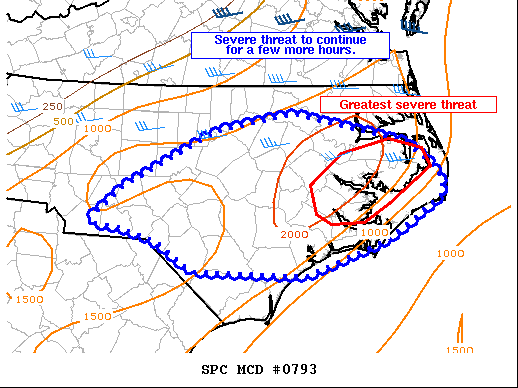
   Mesoscale Discussion 0793
   NWS Storm Prediction Center Norman OK
   0512 PM CDT Mon May 16 2022

   Areas affected...Central and Eastern North Carolina

   Concerning...Severe Thunderstorm Watch 228...

   Valid 162212Z - 162315Z

   The severe weather threat for Severe Thunderstorm Watch 228
   continues.

   SUMMARY...The severe weather threat will continue for a few more
   hours.

   DISCUSSION...A few supercells and multicell clusters continue within
   watch 228. The strongest storms are in eastern portions of the watch
   where the greatest instability is present. Farther west, the airmass
   ahead of these storms has cooled as an outflow boundary has surged
   ahead. Therefore, enough instability exists in a moderate shear
   environment (30-35 knots) to support some severe weather threat, but
   the greater threat remains farther east. The severe weather threat
   remains more questionable in southern portions of watch 228. A few
   weak storms have developed in northern South Carolina, but have
   remained sub-severe thus far. This airmass has not been impacted by
   earlier convection, but dewpoints have mixed into the low 60s.
   Therefore, some strong to severe storms are possible, especially
   near the sea breeze boundary where greater low-level moisture is
   present, but the lesser instability may also preclude more robust
   thunderstorm development.

   ..Bentley.. 05/16/2022

   ...Please see www.spc.noaa.gov for graphic product...

   ATTN...WFO...AKQ...MHX...RAH...ILM...GSP...

   LAT...LON   35647947 36037869 36237763 35897606 35577562 35307555
               34807630 34397747 34447900 34777952 34928003 34988047
               35378000 35647947
|
|
Top/All Mesoscale Discussions/Forecast Products/Home
|
|


 @NWSSPC