|
| Mesoscale Discussion 798 |
|
< Previous MD Next MD >
|
|
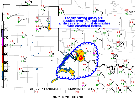
   Mesoscale Discussion 0798
   NWS Storm Prediction Center Norman OK
   1247 AM CDT Tue May 17 2022

   Areas affected...southwest OK and northwestern TX

   Concerning...Severe Thunderstorm Watch 234...

   Valid 170547Z - 170645Z

   The severe weather threat for Severe Thunderstorm Watch 234
   continues.

   SUMMARY...Locally strong gusts may continue across the remainder of
   WW 234, but the severe threat is expected to diminish over the next
   hour.

   DISCUSSION...A cluster of storms across southwest OK into northwest
   TX will continue to track eastward the next couple of hours. Latest
   radar loops from KFDR show a large outflow boundary has begun to
   propagate eastward ahead of these storms. The Oklahoma Mesonet site
   at Granfield measured a 52 mph gust in the past 15 minutes, with
   other sites measuring gusts in the upper 40 mph range. While some
   locally strong gusts may occur with the surging outflow,
   boundary-layer inhibition and weakening convection over the next
   hour or so should limit severe potential. Given latest trends, a
   downstream watch/watch extension is not expected.

   ..Leitman.. 05/17/2022

   ...Please see www.spc.noaa.gov for graphic product...

   ATTN...WFO...OUN...LUB...

   LAT...LON   33770002 34429929 34789887 34919850 34799807 34279798
               33839804 33549839 33409922 33459985 33470004 33770002
|
|
Top/All Mesoscale Discussions/Forecast Products/Home
|
|


 @NWSSPC