|
| Mesoscale Discussion 819 |
|
< Previous MD Next MD >
|
|
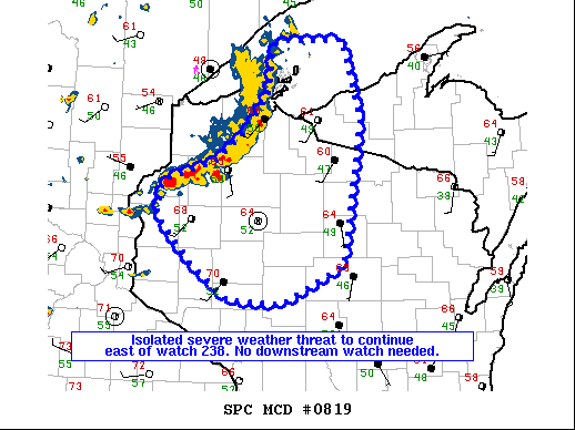
   Mesoscale Discussion 0819
   NWS Storm Prediction Center Norman OK
   0550 PM CDT Wed May 18 2022

   Areas affected...Northern Wisconsin into the western Michigan Upper
   Peninsula.

   Concerning...Severe potential...Watch unlikely

   Valid 182250Z - 182345Z

   Probability of Watch Issuance...5 percent

   SUMMARY...An isolated large hail/damaging wind threat will continue
   east of watch 238. No downstream watch is needed.

   DISCUSSION...A well-developed squall line will continue southeast
   through the evening. The WSR-88D in Duluth is sampling 50-60 mph
   winds along this line and recently a 59 mph wind gust was measured
   in Ashland, Wisconsin. Therefore, a damaging wind threat continues
   for now. In addition, cold temperatures aloft are supporting
   marginally severe hail with a 1 inch hail report in Pine County,
   Minnesota at 22Z. However, this line of storms is moving toward a
   more stable airmass with dewpoints in the 40s and a cooling boundary
   layer. Therefore, the severe weather threat is expected to
   lessen/become more isolated through the remainder of the evening
   with no downstream watch anticipated.

   ..Bentley/Guyer.. 05/18/2022

   ...Please see www.spc.noaa.gov for graphic product...

   ATTN...WFO...MQT...GRB...DLH...ARX...MPX...

   LAT...LON   45069196 45539248 45909238 46089164 46419117 46809084
               47159080 47339073 47358975 46518950 45058976 44649065
               44699142 45069196
|
|
Top/All Mesoscale Discussions/Forecast Products/Home
|
|


 @NWSSPC