|
| Mesoscale Discussion 820 |
|
< Previous MD Next MD >
|
|
Mesoscale Discussion 0820
NWS Storm Prediction Center Norman OK
0757 PM CDT Wed May 18 2022
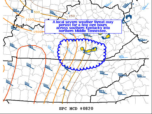
Areas affected...South-central Kentucky into northern middle
Tennessee
Concerning...Severe Thunderstorm Watch 240...
Valid 190057Z - 190230Z
The severe weather threat for Severe Thunderstorm Watch 240
continues.
SUMMARY...A local severe weather threat may persist for a few more
hours across southern Kentucky and into northern Middle Tennessee.
No downstream watch is anticipated.
DISCUSSION...A cluster of supercells has developed on the western
periphery of an ongoing storm cluster across central/south-central
Kentucky. The modified 00Z BNA RAOB shows around 1000 J/kg of MLCAPE
and near 50 knots of effective shear in the vicinity of these
supercells. This should be sufficient for a sustained severe weather
threat for a few more hours, especially with the strengthening
low-level jet (~35 knots on the OHX VWP). A tornado or two cannot be
ruled out with the stronger supercells given the moderately strong
ongoing mesocyclones and 0-1 SRH around 200 m2/s2 (per OHX VWP).
This cluster of storms may eventually move out of watch 240 into
northern Tennessee. However, a downstream watch will likely not be
issued due to the localized nature of the threat and an increasingly
hostile thermodynamic environment as these storms continue
southeast.
..Bentley/Bunting.. 05/19/2022
...Please see www.spc.noaa.gov for graphic product...
ATTN...WFO...MRX...JKL...LMK...OHX...
LAT...LON 37348565 37378445 37158360 36608365 36388404 36278495
36408551 36568568 36818580 37038581 37348565
|
|
Top/All Mesoscale Discussions/Forecast Products/Home
|
|


 @NWSSPC