|
| Mesoscale Discussion 994 |
|
< Previous MD Next MD >
|
|
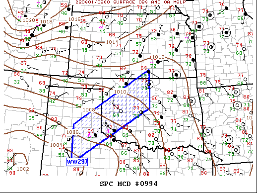
   Mesoscale Discussion 0994
   NWS Storm Prediction Center Norman OK
   0929 PM CDT Tue May 31 2022

   Areas affected...Southern Plains

   Concerning...Severe Thunderstorm Watch 297...

   Valid 010229Z - 010330Z

   The severe weather threat for Severe Thunderstorm Watch 297
   continues.

   SUMMARY...Convection is expected to linger across the southern
   Plains region; however, it's not clear whether a new watch is
   currently warranted, though a local extension may be necessary.

   DISCUSSION...Slow-moving convection that initiated shortly after
   peak heating along the front continues this evening. Southern-most
   complex of storms has propagated into the southwestern portions of
   ww297 while a less organized cluster extends along the frontal
   corridor from northwest OK-southeast KS, with more isolated activity
   now slowly evolving into northern MO. In the absence of large-scale
   support aloft, 25kt LLJ and weak frontal convergence are the primary
   mechanisms for convection continuing. MRMS MESH cores have gradually
   weakened over the last hour or so with most updrafts now producing
   marginally severe hail. Gusty winds are also common with the
   northwest TX/southwest OK convection, primarily due to warmer
   surface temperatures and lingering steep low-level lapse rates.
   While this activity is not expected to completely die off any time
   soon, it's not real clear whether a new severe thunderstorm watch is
   warranted given the recent trends and marginal nature of forcing.

   Local watch extension may be necessary.

   ..Darrow.. 06/01/2022

   ...Please see www.spc.noaa.gov for graphic product...

   ATTN...WFO...ICT...OUN...LUB...AMA...

   LAT...LON   34870149 37419734 35679734 33140148 34870149
|
|
Top/All Mesoscale Discussions/Forecast Products/Home
|
|


 @NWSSPC