|
| Mesoscale Discussion 997 |
|
< Previous MD Next MD >
|
|
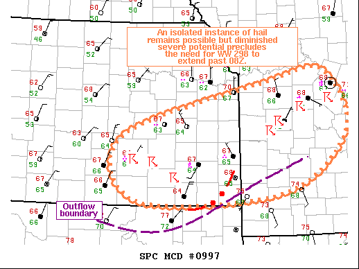
   Mesoscale Discussion 0997
   NWS Storm Prediction Center Norman OK
   0217 AM CDT Wed Jun 01 2022

   Areas affected...Southeast KS...West-Central MO

   Concerning...Severe Thunderstorm Watch 298...

   Valid 010717Z - 010815Z

   The severe weather threat for Severe Thunderstorm Watch 298
   continues.

   SUMMARY...Severe Thunderstorm Watch 298 will be allowed to expire at
   08Z.

   DISCUSSION...A large area of thunderstorms persists from southeast
   KS into central MO. Cold pool associated with these storms has
   surged south to near the KS/OK, evidenced by the mid 60s
   temperatures across much of southeast KS. Additional thunderstorms
   are possible as a modest low-level jet contributes to warm-air
   advection across this outflow. However, persistent convection over
   the region has eliminated the steep mid-level lapse rates once in
   place, limiting the overall severe potential. While a strong updraft
   or two capable of isolated hail remains possible, the overall severe
   potential has diminished enough to allow Severe Thunderstorms Watch
   298 to expire at 08Z.

   ..Mosier.. 06/01/2022

   ...Please see www.spc.noaa.gov for graphic product...

   ATTN...WFO...LSX...SGF...EAX...TOP...ICT...

   LAT...LON   38129705 39009400 39179287 38179242 37199373 37089672
               38129705
|
|
Top/All Mesoscale Discussions/Forecast Products/Home
|
|


 @NWSSPC