|
| Mesoscale Discussion 1006 |
|
< Previous MD Next MD >
|
|
Mesoscale Discussion 1006
NWS Storm Prediction Center Norman OK
0558 PM CDT Wed Jun 01 2022
Areas affected...Portions of western north TX
Concerning...Severe potential...Watch unlikely
Valid 012258Z - 020100Z
Probability of Watch Issuance...20 percent
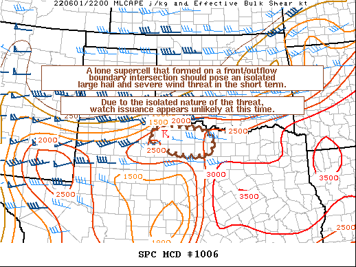
SUMMARY...A lone supercell that formed on a front/outflow boundary
intersection should pose an isolated large hail and severe wind
threat in the short term. Due to the isolated nature of the threat,
watch issuance appears unlikely at this time.
DISCUSSION...A single supercell is ongoing early this evening over
Foard and Knox Counties in western north TX. Recent visible
satellite imagery and surface observations suggest that this
thunderstorm formed on the intersection of a cold front and outflow
boundary from prior convection. Around 2000-2500 J/kg of MLCAPE is
present along/near the outflow boundary. Although low-level winds
are weak per recent VWPs from KDYX, easterly boundary-layer flow
veers quickly to westerly at mid levels while modestly
strengthening. Corresponding 30-40 kt of effective bulk shear should
prove favorable for continued convective organization in the short
term, and large hail nearing 2 inches in diameter appears possible
with the lone supercell. Strong to severe downdraft winds may also
occur. At this point, nebulous large-scale forcing aloft suggests
the overall severe threat will probably remain too isolated to
justify watch issuance. But, trends will be closely monitored
through the evening.
..Gleason/Hart.. 06/01/2022
...Please see www.spc.noaa.gov for graphic product...
ATTN...WFO...FWD...OUN...SJT...LUB...
LAT...LON 33419997 33680009 33939982 33969943 33819800 33339765
33049805 33079895 33229955 33419997
|
|
Top/All Mesoscale Discussions/Forecast Products/Home
|
|


 @NWSSPC