|
| Mesoscale Discussion 1021 |
|
< Previous MD Next MD >
|
|
Mesoscale Discussion 1021
NWS Storm Prediction Center Norman OK
0224 PM CDT Fri Jun 03 2022
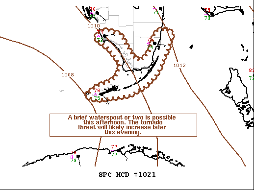
Areas affected...Southern Florida Peninsula
Concerning...Severe potential...Watch unlikely
Valid 031924Z - 032130Z
Probability of Watch Issuance...5 percent
SUMMARY...A waterspout or two is possible through the afternoon
hours along the southern Florida coast and across the Florida Keys
as low-level wind shear increases. However, buoyancy will remain a
limiting factor until later tonight.
DISCUSSION...Shallow convection associated with a potential tropical
cyclone (currently off the west coast of Cuba) has begun to
overspread the waters off the southern FL Peninsula and the FL keys.
Recent mesoanalysis and VWP observations have all shown an increase
in 0-1 km SRH over the past 1-2 hours as the low approaches the
region. This has allowed shallow convective showers to take on
supercell-like organization with weak mesocyclones. 0-1 km helicity
should continue to slowly increase as the low moves northeast.
500-1000 J/kg MLCAPE over the warmer ocean surface (where buoys are
observing temperatures in the upper 70s/low 80s) will continue to
support the potential for organized shallow convection. Persistent
rainfall onshore has limited diurnal warming (temperatures in the
low to mid 70s) and overall instability. Consequently, the tornado
threat will largely remain offshore for the afternoon, though a
waterspout or two along the immediate FL coast is possible. The
tornado threat will spread inland later this evening/tonight as
higher theta-e air is advected north in tandem with strengthening
low-level wind fields associated with the low.
..Moore/Guyer.. 06/03/2022
...Please see www.spc.noaa.gov for graphic product...
ATTN...WFO...MFL...KEY...
LAT...LON 24418190 24508219 24718190 24948134 25318122 25708155
25958193 26158173 26058125 25658100 25438087 25368065
25638040 26118025 26187997 26057980 25637995 25108020
24738053 24528100 24418190
|
|
Top/All Mesoscale Discussions/Forecast Products/Home
|
|


 @NWSSPC