|
| Mesoscale Discussion 1039 |
|
< Previous MD Next MD >
|
|
Mesoscale Discussion 1039
NWS Storm Prediction Center Norman OK
0312 PM CDT Sun Jun 05 2022
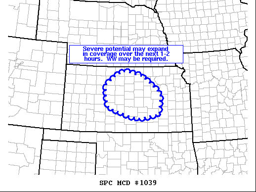
Areas affected...parts of northern and central Kansas
Concerning...Severe potential...Watch possible
Valid 052012Z - 052215Z
Probability of Watch Issuance...40 percent
SUMMARY...Convection developing over portions of north-central
Kansas seems likely to increase in coverage over the next couple of
hours, turning southeastward with time. WW may be required.
DISCUSSION...Latest radar loop shows a small cluster of strong
updrafts over the Phillips/Rooks County KS vicinity, northeast of
the more cloudy/capped airmass that lingers across southwestern KS
at this time. This convection is occurring within the gradient on
the eastern fringe of the axis of greatest mixed-layer CAPE over
western Kansas, but still within a thermodynamic environment
sufficient to support severe potential -- mainly in the form of
large hail.
Various CAM runs differ with respect to convective evolution with
time, and given effects of the prior/overnight MCS, uncertainty
persists in the short term. Still, it appears likely that this
cluster will gradually increase in coverage, and shift southeastward
with time, on the northeastern fringe of the more capped
environment. Given the amply veering/increasing flow field with
height supporting potential for severe weather, watch issuance is
being considered for portions of the central Kansas vicinity.
..Goss/Guyer.. 06/05/2022
...Please see www.spc.noaa.gov for graphic product...
ATTN...WFO...TOP...ICT...GID...DDC...
LAT...LON 39189954 39579903 39809853 39589744 38799637 37829647
37639777 38099939 38789959 39189954
|
|
Top/All Mesoscale Discussions/Forecast Products/Home
|
|


 @NWSSPC