|
| Mesoscale Discussion 1067 |
|
< Previous MD Next MD >
|
|
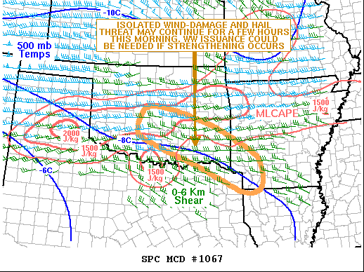
   Mesoscale Discussion 1067
   NWS Storm Prediction Center Norman OK
   0744 AM CDT Tue Jun 07 2022

   Areas affected...South-central and Southeast Oklahoma into Southwest
   Arkansas and far Northeast Texas

   Concerning...Severe potential...Watch possible

   Valid 071244Z - 071515Z

   Probability of Watch Issuance...40 percent

   SUMMARY...An isolated severe threat, with wind damage and hail
   potential, may continue for several more hours across parts of
   south-central and southeast Oklahoma, and possibly affecting parts
   of the Arklatex. WW issuance could be needed if organization occurs
   with the cluster of storms.

   DISCUSSION...The latest high-resolution radar from Oklahoma City
   shows a cluster of strong to severe thunderstorms oriented from
   west-northwest to the east-southeast. The cluster is located along
   the southern edge of a corridor of moderate instability, along which
   MLCAPE is estimated by the RAP in the 1000 to 2000 J/kg range. In
   addition, the Oklahoma City WSR-88D VWP has 0-6 km shear near 45
   knots with speed shear in the mid-levels. This could be an
   environment favorable for damaging wind gusts, especially if a cold
   pool can organize with the current cluster. Large hail would be
   possible in the stronger cores. If the cluster remains in a more
   east-to-west orientation, then some weakening would be expected this
   morning.

   ..Broyles/Grams.. 06/07/2022

   ...Please see www.spc.noaa.gov for graphic product...

   ATTN...WFO...LZK...SHV...TSA...FWD...OUN...

   LAT...LON   34719798 34269699 33779577 33259472 32909393 32999344
               33289324 33729329 34099348 34589423 34999497 35429610
               35679707 35699767 35519793 35119810 34719798
|
|
Top/All Mesoscale Discussions/Forecast Products/Home
|
|


 @NWSSPC