|
| Mesoscale Discussion 1110 |
|
< Previous MD Next MD >
|
|
Mesoscale Discussion 1110
NWS Storm Prediction Center Norman OK
0256 AM CDT Fri Jun 10 2022
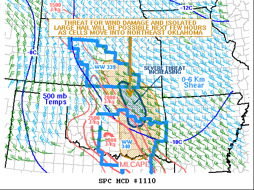
Areas affected...Southern Kansas...Northern and Eastern Oklahoma
Concerning...Severe Thunderstorm Watch 339...340...
Valid 100756Z - 101000Z
The severe weather threat for Severe Thunderstorm Watch 339, 340
continues.
SUMMARY...A severe threat is expected to continue as cells move
southeastward from southeast Kansas into northern and eastern
Oklahoma. Wind damage and isolated large hail will be the main
threats. A local extension in area for parts of northeastern
Oklahoma between the two ongoing watches may be needed.
DISCUSSION...The latest mosaic radar imagery from southern Kansas
into east-central Oklahoma shows an MCS that is organizing in two
parts. The first part is in southeast Kansas along an
northwest-to-southeast gradient of instability, where the RAP has
MLCAPE in the 500 to 1500 J/kg range. The second is in central
Oklahoma, where a pocket of moderate to strong instability exists,
with the RAP estimating MLCAPE as great as 3000 J/kg. The two areas
of storms are expected to combine into one large MCS, with the
stronger part of the MCS moving southeastward across parts of
northeast and east-central Oklahoma. Although the severe threat will
continue within the ongoing watches, an extension in area between
the two watches may be needed for the developing severe threat in
northeast Oklahoma.
..Broyles.. 06/10/2022
...Please see www.spc.noaa.gov for graphic product...
ATTN...WFO...SHV...TSA...ICT...FWD...OUN...
LAT...LON 38039810 37619829 37089801 35779715 34699702 33979692
33699624 33709591 34049505 34769483 35419475 35909481
36069481 36629507 37179565 37929645 38269699 38249769
38169796 38039810
|
|
Top/All Mesoscale Discussions/Forecast Products/Home
|
|


 @NWSSPC