|
| Mesoscale Discussion 1121 |
|
< Previous MD Next MD >
|
|
Mesoscale Discussion 1121
NWS Storm Prediction Center Norman OK
0717 PM CDT Sat Jun 11 2022
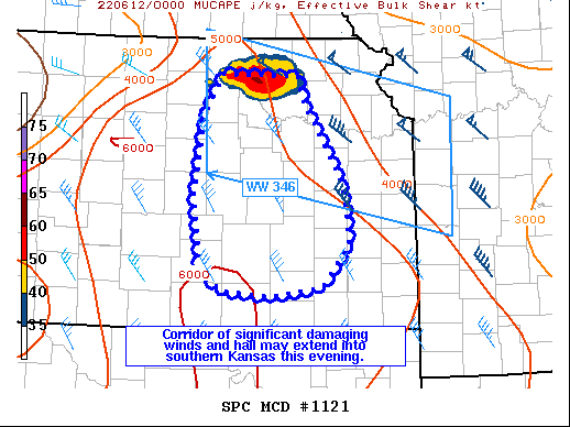
Areas affected...parts of eastern Kansas
Concerning...Severe Thunderstorm Watch 345...346...
Valid 120017Z - 120215Z
The severe weather threat for Severe Thunderstorm Watch 345, 346
continues.
SUMMARY...A corridor of significant damaging winds and hail remains
possible over parts of eastern Kansas. A tornado may also occur.
Localized gusts of 80-100 mph are possible. An additional watch may
also be needed into parts of southern Kansas.
DISCUSSION...Storms that crossed south out of Nebraska have merged
into a convective complex with periodic mesocyclones, now moving
into Riley and Pottawatomie Counties, and soon I-70. This complex
continues to have an impressive satellite presentation, and a very
moist and unstable air mass remains ahead of it. The system has been
moving south at close to 30 kt, with a small degree of backbuilding
toward the west. Recent radar trends also indicate a growing area of
severe outflow, and this may persist for several hours,
necessitating the need for another watch to the south.
..Jewell.. 06/12/2022
...Please see www.spc.noaa.gov for graphic product...
ATTN...WFO...TOP...ICT...
LAT...LON 39639716 39619617 39349608 39069590 38479557 37879550
37459585 37349651 37399714 37609743 38379753 39249739
39639716
|
|
Top/All Mesoscale Discussions/Forecast Products/Home
|
|


 @NWSSPC