|
| Mesoscale Discussion 1157 |
|
< Previous MD Next MD >
|
|
Mesoscale Discussion 1157
NWS Storm Prediction Center Norman OK
1042 PM CDT Mon Jun 13 2022
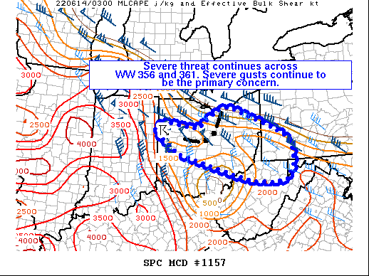
Areas affected...Parts of OH...southwest PA...northern WV...and far
western MD
Concerning...Severe Thunderstorm Watch 356...361...
Valid 140342Z - 140545Z
The severe weather threat for Severe Thunderstorm Watch 356, 361
continues.
SUMMARY...Severe wind gusts remain the primary concern across Severe
Thunderstorm Watches 356 and 361.
DISCUSSION...A mature convective line across parts of northern Ohio
will continue tracking east-southeastward at around 50 kt into the
overnight hours, while an additional convective cluster farther west
over northwest Ohio continues southeastward at around 35 kt. Farther
south, a large cold pool is evident over parts of WV in the wake of
a now decaying MCS moving into far western VA. North of the cold
pool, a narrow corridor of rich boundary-layer moisture (lower 70s
dewpoints) and surface-based instability remains in place. Given
that inflow will likely be rooted at or near the surface along this
corridor, effective bulk shear near 30-40 kt perpendicular to the
convective line could support its maintenance toward the southeast.
Trends will continue to be monitored, and a new watch could
eventually be needed downstream of Severe Thunderstorm Watch 361.
..Weinman/Thompson.. 06/14/2022
...Please see www.spc.noaa.gov for graphic product...
ATTN...WFO...CTP...LWX...PBZ...RLX...CLE...ILN...IWX...
LAT...LON 40988457 40778310 41338237 41468182 40577960 40127927
39577923 39127950 39038004 39098087 39278153 39978397
40698495 40988457
|
|
Top/All Mesoscale Discussions/Forecast Products/Home
|
|


 @NWSSPC