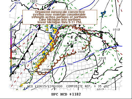
   Mesoscale Discussion 1182
   NWS Storm Prediction Center Norman OK
   0703 PM CDT Wed Jun 15 2022

   Areas affected...eastern Wisconsin to the upper peninsula of
   Michigan and northern lower Michigan

   Concerning...Tornado Watch 371...372...

   Valid 160003Z - 160130Z

   The severe weather threat for Tornado Watch 371, 372 continues.

   SUMMARY...The organized cluster of storms may maintain considerable
   strength across at least portions of northern Lake Michigan into
   northern lower Michigan by 9-11 PM EDT, posing a risk for
   potentially damaging wind gusts.  It is not certain a new severe
   weather watch will be needed, but trends are being monitored for
   this possibility.

   DISCUSSION...An organized mesoscale convective system has evolved,
   with a number of embedded lower/mid tropospheric cyclonic
   circulations, pockets of strengthening rear inflow and near surface
   meso-vortices.  As a rapid forward (northeastward and eastward)
   propagation continues, the impacts of a less unstable, more
   inhibited boundary-layer near and east of Lake Michigan are unclear.
   Rapid Refresh suggests that a drier lower/mid tropospheric air mass
   is advecting northward through southern portions of Lake Michigan,
   but a more moist environment farther north, coupled with lift
   associated warm advection, may maintain vigorous slightly elevated
   storms across northern Lake Michigan into northern lower Michigan by
   01-03Z.  This could be accompanied by at least a continuing risk for
   localized damaging wind gusts.

   ..Kerr.. 06/16/2022

   ...Please see www.spc.noaa.gov for graphic product...

   ATTN...WFO...APX...GRR...MQT...GRB...MKX...

   LAT...LON   44988755 45578725 46318707 46548578 45908346 45138357
               44648440 44338536 43998685 42568860 42588954 43978841
               44988755
|


 @NWSSPC