|
| Mesoscale Discussion 1195 |
|
< Previous MD Next MD >
|
|
Mesoscale Discussion 1195
NWS Storm Prediction Center Norman OK
0434 PM CDT Thu Jun 16 2022
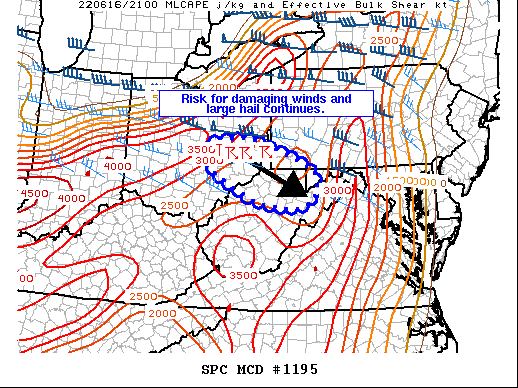
Areas affected...Southeastern Ohio..southwest
Pennsylvania...northern West Virginia
Concerning...Severe Thunderstorm Watch 375...
Valid 162134Z - 162300Z
The severe weather threat for Severe Thunderstorm Watch 375
continues.
SUMMARY...Damaging winds and large hail will remain possible with a
southeastward moving cluster of supercells. With shear diminishing
to the south, the severe threat may become more isolated with time.
Depending on trends, a new downstream watch could be needed.
DISCUSSION...A cluster of supercell thunderstorms continues to move
southeastward through southeast Ohio and into southwestern
Pennsylvania. Radar imagery over the last hour or so from KPBZ shows
that storm organization may be on the decrease. This is in part due
to interactions between the nearby storms as well as being farther
removed from the stronger mid-level winds to the north. As these
storms continue into parts of West Virginia, the thermodynamic
environment will remain similar while the shear, as mentioned, will
continue to weaken. Given the current organization of the storms, at
least some threat for damaging winds and large hail will exist into
West Virginia. Depending on convective trends, this may warrant a
new severe thunderstorm watch.
..Wendt.. 06/16/2022
...Please see www.spc.noaa.gov for graphic product...
ATTN...WFO...CTP...LWX...PBZ...RLX...CLE...ILN...
LAT...LON 40278234 40378209 40438114 40128022 39667923 39317916
38987929 38827979 38928079 39198142 39648221 40068250
40278234
|
|
Top/All Mesoscale Discussions/Forecast Products/Home
|
|


 @NWSSPC