|
| Mesoscale Discussion 1196 |
|
< Previous MD Next MD >
|
|
Mesoscale Discussion 1196
NWS Storm Prediction Center Norman OK
0505 PM CDT Thu Jun 16 2022
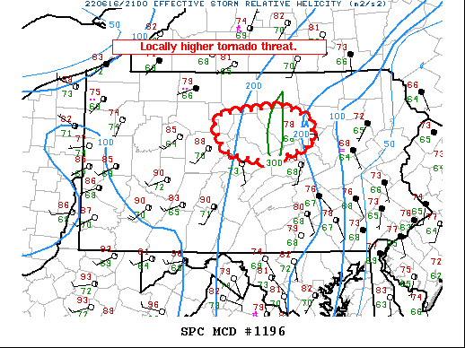
Areas affected...Parts of central Pennsylvania
Concerning...Tornado Watch 376...
Valid 162205Z - 162300Z
The severe weather threat for Tornado Watch 376 continues.
SUMMARY...A locally higher tornado threat is evident in
north-central Pennsylvania with two ongoing supercells.
DISCUSSION...Two supercells are ongoing north of State College. The
western cells has generally exhibited outflow-dominant
characteristics on KCCX radar. The eastern cell developed recently
along a stationary boundary within central Pennsylvania. While the
thermodynamic environment in eastern Pennsylvania becomes less
favorable, a narrow window for a locally higher tornado threat is
evident given the backed surface winds in north-central Pennsylvania
and consequently higher effective SRH. This threat may continue for
another 1-1.5 hours or until storms ingest far less buoyant air to
the east.
..Wendt.. 06/16/2022
...Please see www.spc.noaa.gov for graphic product...
ATTN...WFO...CTP...
LAT...LON 40867742 40987806 41137823 41347828 41477819 41577718
41417671 41097667 40867742
|
|
Top/All Mesoscale Discussions/Forecast Products/Home
|
|


 @NWSSPC