|
| Mesoscale Discussion 1267 |
|
< Previous MD Next MD >
|
|
Mesoscale Discussion 1267
NWS Storm Prediction Center Norman OK
0356 PM CDT Thu Jun 23 2022
Areas affected...Far northeast SD into central MN
Concerning...Severe potential...Watch possible
Valid 232056Z - 232330Z
Probability of Watch Issuance...40 percent
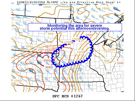
SUMMARY...The area is being monitored for possible severe storm
development this afternoon and evening. While uncertain, a watch
could eventually be needed for parts of northeast SD into central
MN.
DISCUSSION...Visible satellite imagery shows a modest uptick in
boundary-layer cumulus along a weak surface trough extending across
parts of central MN into northeast SD. While boundary-layer flow is
veered south of the surface boundary, weak low-level warm advection
is supporting a modest increase in low-level confluence. Earlier 12Z
soundings over the northern Plains showed a plume of steep midlevel
lapse rates which has now overspread parts of MN per RAP
mesoanalysis. The steep midlevel lapse rates atop a
moist/deeply-mixed boundary layer are contributing to
moderate/strong surface-based buoyancy -- strongest over northeast
SD into western MN where surface temperatures have climbed into the
middle/upper 90s beneath the core of the steeper lapse rates.
As diurnal destabilization continues amid the modest low-level
confluence, isolated to widely scattered storm development may occur
over parts of northeast SD into central MN this afternoon/evening.
While deep-layer flow/shear is modest (25-35 kt of effective shear),
the favorable buoyancy and at least some deep-layer shear could
support isolated large hail initially. Eventually, damaging winds
could become an increasing concern with any convective clustering
amid the steep low/mid-level lapse rates. Overall confidence in
storm development and maintenance is limited, though trends are
being monitored and a watch could eventually be needed.
..Weinman/Grams.. 06/23/2022
...Please see www.spc.noaa.gov for graphic product...
ATTN...WFO...DLH...MPX...FGF...ABR...
LAT...LON 45909717 46649588 47299380 47309313 47029274 46489254
45809276 45389329 44879655 45059710 45519732 45909717
|
|
Top/All Mesoscale Discussions/Forecast Products/Home
|
|


 @NWSSPC