|
| Mesoscale Discussion 1311 |
|
< Previous MD Next MD >
|
|
Mesoscale Discussion 1311
NWS Storm Prediction Center Norman OK
0629 PM CDT Thu Jun 30 2022
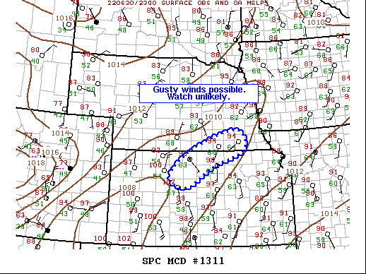
Areas affected...Southern NE...Northern KS
Concerning...Severe potential...Watch unlikely
Valid 302329Z - 010130Z
Probability of Watch Issuance...20 percent
SUMMARY...Gusty winds with isolated 50kt+ wind gusts possible this
evening across southern NE and northern KS.
DISCUSSION...Remnants of a very weak mid-level disturbance, that was
over UT Wednesday evening, have progressed into the central High
Plains. This feature appears to be partly responsible for scattered
convection that is evolving across eastern CO into southern NE.
Latest diagnostic data exhibits a well-defined pre-frontal trough
draped from southeast NE into southwest KS. Temperatures have soared
into the 90s to low 100s along this boundary and scattered storms
are now evolving from southeast of HLC to near HJH. Modest mid-level
flow extends to near the NE/KS border where roughly 25k of flow
exists at 500mb. While shear is not that significant, it appears
adequate flow does exist for the maintenance of at least multicell
updrafts and perhaps some clustering along the surface trough. Given
the steep lapse rates gusty winds are certainly possible, along with
isolated 50kt+ winds. Even so, at this time it does not appear the
severe risk will be widespread enough to warrant a watch. Convection
should spread east along the KS/NE border over the next several
hours.
..Darrow/Guyer.. 06/30/2022
...Please see www.spc.noaa.gov for graphic product...
ATTN...WFO...OAX...TOP...ICT...GID...DDC...
LAT...LON 39229958 40069861 40669684 40039653 39559771 38859894
39229958
|
|
Top/All Mesoscale Discussions/Forecast Products/Home
|
|


 @NWSSPC