Mesoscale Discussion 1312
NWS Storm Prediction Center Norman OK
0641 PM CDT Thu Jun 30 2022
Areas affected...portions of the Upper Michigan Peninsula
Concerning...Severe Thunderstorm Watch 416...
Valid 302341Z - 010145Z
The severe weather threat for Severe Thunderstorm Watch 416
continues.
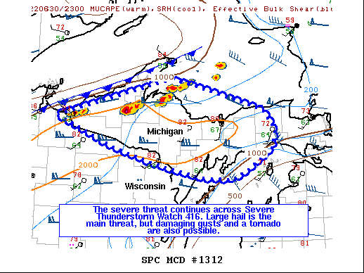
SUMMARY...The severe threat continues across Severe Thunderstorm
Watch 416. Large hail is the primary threat with the more intense
storms, but a couple damaging gusts or a tornado also cannot be
ruled out.
DISCUSSION...Earlier storms moving onto the Upper MI Peninsula have
obtained supercell structures within the last hour or so, with
mainly small hail reported. KMQT and MRMS mosaic radar data show
these storms continuing to intensify, with severe MESH and
appreciable low- and mid-level rotation becoming more evident.
Modified RAP forecast soundings depict relatively moist low level
overspread by 8-9 C/km 700-500 mb lapse rates, contributing to
1500-2000 J/kg MLCAPE. In addition to this moderate buoyancy,
strengthening and veering vertical wind profiles are resulting in
50-70 kts of effective bulk shear, favoring continued storm
organization/strengthening. Large hail will remain a concern with
the stronger storms through the early evening hours. Downstream of
the storms, greater low-level shear is present, with RAP forecast
soundings and APX VWPs showing relatively large, curved 0-3 km
hodographs. 23Z mesoanalysis shows over 200 m2/s2 effective SRH
across central and eastern parts of the Upper MI Peninsula. As such,
a tornado cannot be ruled out with the more discrete, inflow
dominant supercells this evening.
..Squitieri.. 06/30/2022
...Please see www.spc.noaa.gov for graphic product...
ATTN...WFO...APX...MQT...GRB...DLH...
LAT...LON 46519047 47128785 47018723 46638572 46318542 46008548
45718599 45518642 45548710 45778822 46038919 46519047
|


 @NWSSPC