|
| Mesoscale Discussion 1353 |
|
< Previous MD Next MD >
|
|
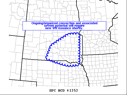
   Mesoscale Discussion 1353
   NWS Storm Prediction Center Norman OK
   1240 AM CDT Mon Jul 04 2022

   Areas affected...eastern South Dakota and far northeastern Nebraska

   Concerning...Severe potential...Watch likely

   Valid 040540Z - 040630Z

   CORRECTED HEADLINE

   Probability of Watch Issuance...95 percent

   SUMMARY...A well-organized/bowing band of storms moving eastward
   across central/southern South Dakota will require new WW issuance,
   to cover ongoing/future severe potential.

   DISCUSSION...A band of strong to severe storms is currently crossing
   central/south-central South Dakota, where a moist/moderately
   unstable environment persists.

   Downstream from the convection, a zone of up to 2500 J/kg
   mixed-layer CAPE is indicated by RAP-based objective analyses.
   This, combined with 40 to 50 kt southerly low-level jet -- and
   associated warm advection/ascent -- suggests likelihood that storms
   will remain well-organized over the next few hours.  Given potential
   for damaging wind gusts, as well as possible instances of marginally
   severe hail, a new WW will be coordinated shortly.

   ..Goss/Edwards.. 07/04/2022

   ...Please see www.spc.noaa.gov for graphic product...

   ATTN...WFO...FSD...OAX...ABR...LBF...UNR...

   LAT...LON   43170098 44370045 45439823 45449694 42689699 42609835
               42789928 43170098
|
|
Top/All Mesoscale Discussions/Forecast Products/Home
|
|


 @NWSSPC