|
| Mesoscale Discussion 1380 |
|
< Previous MD Next MD >
|
|
Mesoscale Discussion 1380
NWS Storm Prediction Center Norman OK
0220 PM CDT Tue Jul 05 2022
Areas affected...central into northeastern Montana
Concerning...Severe potential...Watch possible
Valid 051920Z - 052045Z
Probability of Watch Issuance...40 percent
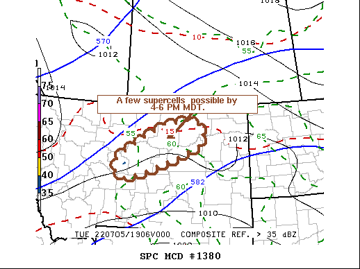
SUMMARY...The development of a couple of supercells posing a risk
for severe hail and locally strong wind gusts appears possible in a
corridor northeast of Lewistown into areas west of Glasgow by 4-6 PM
MDT. Trends are being monitored, but it is not clear that a severe
weather watch will be needed.
DISCUSSION...Low amplitude mid-level troughing is in the process of
progressing across and northeast of the Canadian/northern U.S.
Rockies, with an associated belt 40-50+ kt flow around the 500 mb
level arcing across southwestern through northeastern Montana.
Forcing for ascent associated with at least one speed maximum
embedded within this regime may be aiding ongoing deepening
convective development to the west of the Lewistown area. Aided by
easterly inflow of increasingly unstable boundary layer, convection
appears likely to gradually intensify and advect off the higher
terrain during the next few hours.
As activity develops to the northeast of Lewistown, mixed-layer CAPE
increasing in excess of 1000 J/kg may become supportive of more
substantive intensification, and the evolution of a few supercells
by 22-00Z. This probably will be accompanied by the risk for severe
hail and locally strong surface gusts.
..Kerr/Grams.. 07/05/2022
...Please see www.spc.noaa.gov for graphic product...
ATTN...WFO...BYZ...GGW...TFX...
LAT...LON 47181031 48250818 48440661 47690646 46780914 46621003
47181031
|
|
Top/All Mesoscale Discussions/Forecast Products/Home
|
|


 @NWSSPC