Mesoscale Discussion 1414
NWS Storm Prediction Center Norman OK
0752 PM CDT Thu Jul 07 2022
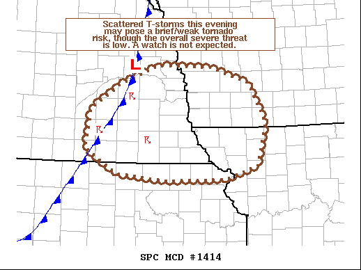
Areas affected...Southeast Nebraska...far northeast
Kansas...northwest Missouri...and southwest Iowa
Concerning...Severe potential...Watch unlikely
Valid 080052Z - 080245Z
Probability of Watch Issuance...5 percent
SUMMARY...Thunderstorms developing in the vicinity of a weak surface
front could become sufficiently intense to pose a threat for severe
wind, hail, and perhaps a brief tornado. This threat will likely
remain too limited to warrant a watch.
DISCUSSION...Over the past hour, thunderstorms have continued to
develop along and ahead of a weak surface cold front across
southeast NE. While most of this convection has remained weak with
little lightning, a few more intense cells have shown transient
signs of weak low-level rotation over the past hour. The environment
across the NE/KS/MO/IA region is sufficiently buoyant for
thunderstorm development, and the southeast to easterly winds in the
lowest 1 km (sampled by surface observations, regional VWPs and
ACARs soundings within the past couple of hours) is supporting 30-35
knots of effective bulk shear. The ACARs sounding and the 00 UTC TOP
RAOB also revealed around 100 m2/s2 of effective SRH, which is
slightly higher than recent mesoanalyses are indicating. Given this
environment and recent observed trends, a brief/weak tornado with
the more robust updrafts is possible. However, confidence in the
overall severe threat is low given the weak lift, meager storm
intensities, and relatively poor storm longevity within this
environment. A watch is not expected.
..Moore/Hart.. 07/08/2022
...Please see www.spc.noaa.gov for graphic product...
ATTN...WFO...DMX...EAX...OAX...TOP...GID...
LAT...LON 41559536 41309454 40659419 39959437 39739504 39729637
39839736 40229803 40869792 41269733 41599648 41559536
|


 @NWSSPC