|
| Mesoscale Discussion 1425 |
|
< Previous MD Next MD >
|
|
Mesoscale Discussion 1425
NWS Storm Prediction Center Norman OK
1130 PM CDT Fri Jul 08 2022
Areas affected...Northeast Montana
Concerning...Severe Thunderstorm Watch 449...
Valid 090430Z - 090600Z
The severe weather threat for Severe Thunderstorm Watch 449
continues.
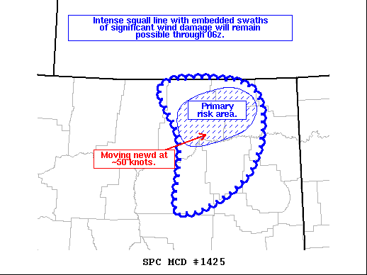
SUMMARY...Intense squall line with embedded bowing structures will
pose a risk of significant wind damage.
DISCUSSION...An intense squall line currently extends across
western/central Valley and central Garfield counties MT, and is
moving east-northeastward at ~50 knots. The air mass ahead of the
storms remains very moist (70+ dewpoints) and unstable with forecast
soundings showing steep mid-level lapse rates and MUCAPE values of
3500-4000 J/kg. Sufficient westerly flow aloft and increasing
mesoscale organization suggest the potential for this bowing
structure to maintain significant intensity as it tracks across WW
449 and into northwest ND. The KGGW VAD profile also shows
relatively strong low-level winds, which could result in isolated
and brief QLCS spin-ups along the leading edge of the most intense
bow structures.
..Hart.. 07/09/2022
...Please see www.spc.noaa.gov for graphic product...
ATTN...WFO...GGW...
LAT...LON 46960697 48030689 48890734 49000581 48740501 48050495
47410537 46970625 46890669 46960697
|
|
Top/All Mesoscale Discussions/Forecast Products/Home
|
|


 @NWSSPC