|
| Mesoscale Discussion 1455 |
|
< Previous MD Next MD >
|
|
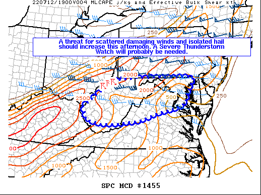
   Mesoscale Discussion 1455
   NWS Storm Prediction Center Norman OK
   1148 AM CDT Tue Jul 12 2022

   Areas affected...Portions of WV into northern VA...western/central
   MD...and DC

   Concerning...Severe potential...Watch possible

   Valid 121648Z - 121915Z

   Probability of Watch Issuance...60 percent

   SUMMARY...A threat for scattered damaging winds and isolated hail
   should increase this afternoon. A Severe Thunderstorm Watch will
   probably be needed.

   DISCUSSION...A couple of thunderstorms have developed as of 1645Z
   near the OH/WV border. This activity is occurring just ahead of a
   weak surface cold front. These thunderstorms and additional
   convective development should spread eastward across much of WV
   through the afternoon. With robust diurnal heating occurring and the
   presence of modestly steepened mid-level lapse rates, around
   1500-2000 J/kg of MLCAPE is expected to be present across the warm
   sector ahead of this activity. This region will be on the southern
   periphery of a strong mid-level jet over the Northeast, but modestly
   enhanced mid-level westerlies should still support around 30-40 kt
   of deep-layer shear. A mix of multicell clusters and marginal
   supercells should occur given the favorable shear. Thunderstorms may
   also develop along a pre-frontal trough over parts of northern
   VA/western MD and vicinity later this afternoon as residual
   convective inhibition eventually erodes. As low-level lapse rates
   steepen and DCAPE increases, damaging downdraft winds will become a
   concern as thunderstorms gradually increase in coverage and
   intensity. Some severe hail may also occur with any cells that can
   remain discrete given the modestly steepened mid-level lapse rates
   aloft. A Severe Thunderstorm Watch will probably be needed in the
   next couple of hours as more convection develops.

   ..Gleason/Thompson.. 07/12/2022

   ...Please see www.spc.noaa.gov for graphic product...

   ATTN...WFO...LWX...RNK...PBZ...RLX...

   LAT...LON   38378242 39578079 39717948 39717616 39507616 39027647
               38587660 38377702 38147825 37837916 37678026 37618129
               37808222 38378242
|
|
Top/All Mesoscale Discussions/Forecast Products/Home
|
|


 @NWSSPC