|
| Mesoscale Discussion 1506 |
|
< Previous MD Next MD >
|
|
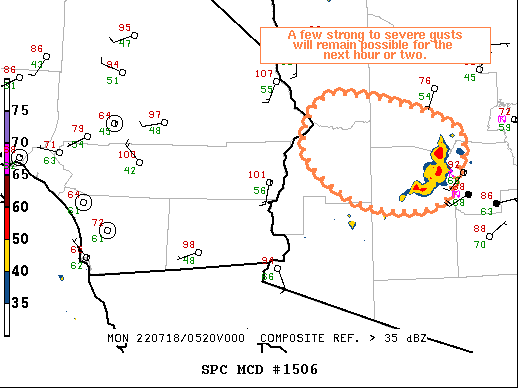
   Mesoscale Discussion 1506
   NWS Storm Prediction Center Norman OK
   1233 AM CDT Mon Jul 18 2022

   Areas affected...Southwest/West-Central AZ

   Concerning...Severe potential...Watch unlikely

   Valid 180533Z - 180730Z

   Probability of Watch Issuance...20 percent

   SUMMARY...A few strong to severe gusts will remain possible for the
   next hour or two downstream of the ongoing convective line across
   west-central AZ.

   DISCUSSION...Cluster of thunderstorms currently west of PHX has
   recently shown some increase in northwesterly motion as the outflow
   surges northwestward. Moderate to strong southeasterly flow is in
   place over the region above 3 km , with weak flow within the deeply
   mixed air mass below 3 km. This cluster has already produced a few
   severe gusts at PHX and LUF, measuring 53 kt and 55 kt,
   respectively.

   Expectation is for this line to continue progressing northwestward
   while maintaining its intensity for the next hour or two. High-based
   character of the storms coupled with the deeply mixed boundary-layer
   and favorable orientation of the deep-layer vertical shear should
   promote the potential for additional strong to severe wind gusts.
   Limited/isolated character of the severe potential should preclude
   the need for a watch.

   ..Mosier/Edwards.. 07/18/2022

   ...Please see www.spc.noaa.gov for graphic product...

   ATTN...WFO...FGZ...PSR...VEF...

   LAT...LON   33291260 33381350 33961423 34611382 34201218 33531225
               33291260
|
|
Top/All Mesoscale Discussions/Forecast Products/Home
|
|


 @NWSSPC