|
| Mesoscale Discussion 1668 |
|
< Previous MD Next MD >
|
|
Mesoscale Discussion 1668
NWS Storm Prediction Center Norman OK
1143 AM CDT Tue Aug 09 2022
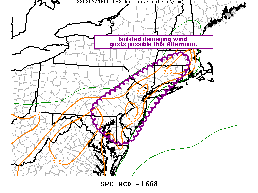
Areas affected...Eastern MD...Southern PA...DE...NJ...Southern
NY..CT...MA...RI
Concerning...Severe potential...Watch unlikely
Valid 091643Z - 091845Z
Probability of Watch Issuance...20 percent
SUMMARY...Isolated damaging wind gusts are possible this afternoon
from the northern Mid-Atlantic into southern New England.
DISCUSSION...Recent surface analysis places a low over southern ME,
with a cold front extending southwestward from this low across the
central Hudson Valley into central PA. A weak trough also precedes
this front. extending southward through central MA and central CT
into northern NJ and far eastern PA. Current surface observations
also reveal dewpoints in the 70s areawide, with numerous locations
reporting dewpoints in mid 70s.
Cumulus continues to deepen in the vicinity of the surface trough as
the air mass heats and destabilizes. This trend is expected to
persist throughout the afternoon, resulting in the development of
scattered thunderstorms. The stronger mid-level flow will be over
ME, displaced north of the stronger buoyancy, which is expected
across the Delmarva, eastern PA, and NJ. Additionally, the overall
instability will be limited by weak mid-level lapse rates and warm
thermodynamic profiles. Even so, steep low-level lapse rates coupled
with a very moist air mass could still support locally damaging wind
gusts with any stronger storms.
..Mosier/Hart.. 08/09/2022
...Please see www.spc.noaa.gov for graphic product...
ATTN...WFO...BOX...OKX...ALY...PHI...BGM...CTP...LWX...
LAT...LON 38717592 39607707 40517661 42477238 41977151 40807305
39687417 38757492 38717592
|
|
Top/All Mesoscale Discussions/Forecast Products/Home
|
|


 @NWSSPC