|
| Mesoscale Discussion 1829 |
|
< Previous MD Next MD >
|
|
Mesoscale Discussion 1829
NWS Storm Prediction Center Norman OK
0331 PM CDT Sun Sep 25 2022
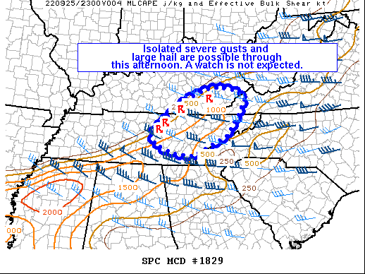
Areas affected...Eastern TN and southeast KY
Concerning...Severe potential...Watch unlikely
Valid 252031Z - 252230Z
Probability of Watch Issuance...20 percent
SUMMARY...Isolated severe gusts and large hail will be possible as
storms track eastward this afternoon. A watch is not currently
expected.
DISCUSSION...Latest radar data from OHX shows a broken band of
loosely organized splitting cells tracking eastward ahead of cold
front moving through Middle TN. OHX VWP data and the BNA 18Z
observed sounding show strong westerly flow aloft, resulting in a
long/straight hodograph characterized by 40-50 kt of effective
shear. Ahead of the convection, cloud clearing has allowed
temperatures to warm into the middle/upper 70s amid middle 60s
dewpoints. These boundary-layer conditions, combined with the
favorable deep-layer shear could result in some modest
intensification of the ongoing convection through the afternoon. The
primary concern will be large hail and locally severe gusts with any
splitting supercell structures or organized clusters. A watch is not
currently expected, though trends will be monitored.
..Weinman/Thompson.. 09/25/2022
...Please see www.spc.noaa.gov for graphic product...
ATTN...WFO...RLX...MRX...JKL...LMK...OHX...
LAT...LON 35948603 36528550 37088469 37388399 37498335 37368262
37088234 36588257 35968303 35288442 35388527 35668591
35948603
|
|
Top/All Mesoscale Discussions/Forecast Products/Home
|
|


 @NWSSPC