|
| Mesoscale Discussion 85 |
|
< Previous MD Next MD >
|
|
Mesoscale Discussion 0085
NWS Storm Prediction Center Norman OK
0829 AM CST Sun Jan 22 2023
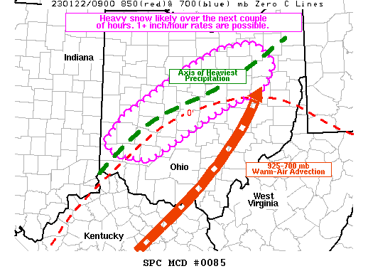
Areas affected...portions of southwest into central Ohio
Concerning...Heavy snow
Valid 221429Z - 221730Z
SUMMARY...Bouts of heavy snow are likely through the morning. 1+
inch/hour rates may briefly occur in spots.
DISCUSSION...Deep-layer warm-air/moisture advection is taking place
across the eastern OH Valley into the central Appalachians in
response to an approaching mid-level trough. Across southwest into
central OH, sub-freezing tropospheric profiles are in place, where
heavy snow reports have also recently been received. RAP forecast
soundings depict near saturation from the surface to 700 mb,
suggesting ample moisture for efficient snowfall production exists
within the dendritic growth zone (roughly -12 to -17C layer). As
such, heavy snow (including 1+ inch/hr rates) may continue for the
next couple of hours across southwest into central OH, as also
depicted by recent runs of the HRRR. Thereafter, the strong warm-air
advection may warm the lower levels to above-freezing temperatures
across eastern OH, where a transition to a wintry mix is likely.
..Squitieri.. 01/22/2023
...Please see www.spc.noaa.gov for graphic product...
ATTN...WFO...PBZ...CLE...ILN...
LAT...LON 39588470 40018435 40678324 41088235 41188160 40908119
40478142 40138236 39618332 39338381 39358400 39418447
39588470
|
|
Top/All Mesoscale Discussions/Forecast Products/Home
|
|


 @NWSSPC