|
| Mesoscale Discussion 294 |
|
< Previous MD Next MD >
|

|
   Mesoscale Discussion 0294
   NWS Storm Prediction Center Norman OK
   0343 PM CDT Thu Mar 16 2023

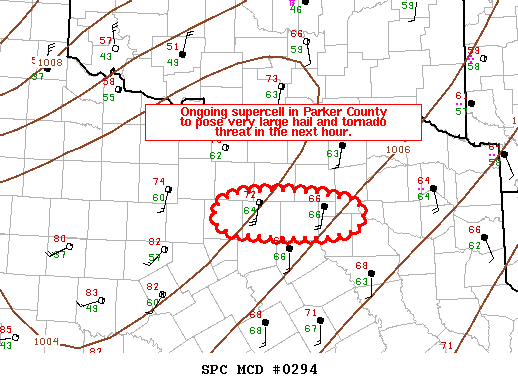
   Areas affected...the Dallas/Fort Worth metroplex and vicinity

   Concerning...Tornado Watch 68...

   Valid 162043Z - 162215Z

   The severe weather threat for Tornado Watch 68 continues.

   SUMMARY...An ongoing supercell in Parker County will pose a locally
   greater threat for very large hail and tornadoes in the Dallas/Forth
   Worth metroplex and vicinity in the next 30-60 minutes.

   DISCUSSION...A discrete supercell has developed in the open warm
   sector ahead of a cold front surging through the Red River Valley. A
   slight right turn roughly 30 mins ago has yielded increasingly
   deviant motion around 275 degrees at around 37 kts. This is around
   15-20 degrees farther right and 5-10 kts faster than the expected
   Bunkers-right storm motion from the current KFWS VAD. This observed
   motion yields roughly 350 J/kg of 0-1-km SRH from the KFWS VAD (>
   250 J/kg of which is concentrated in the lowest 500 m AGL). The
   recent 20z FWD radiosonde revealed some MLCIN (around 40 J/kg) with
   around 1500 J/kg of MLCAPE. Radar and visual observations suggest a
   predominantly HP storm mode which, along with the small amount of
   MLCIN, may be responsible for tempering the tornado threat thus far.
   However, given environmental and radar trends, the threats for a
   significant, impactful hailstorm and some tornadoes are increasing
   for the Dallas/Fort Worth metroplex within the hour.

   ..Flournoy/Squitieri.. 03/16/2023

   ...Please see www.spc.noaa.gov for graphic product...

   ATTN...WFO...FWD...

   LAT...LON   32619762 32689786 32919793 33069769 33129718 33089656
               32989600 32759591 32639607 32579644 32579700 32619762
|
|
Top/All Mesoscale Discussions/Forecast Products/Home
|
|


