|
| Mesoscale Discussion 852 |
|
< Previous MD Next MD >
|
|
Mesoscale Discussion 0852
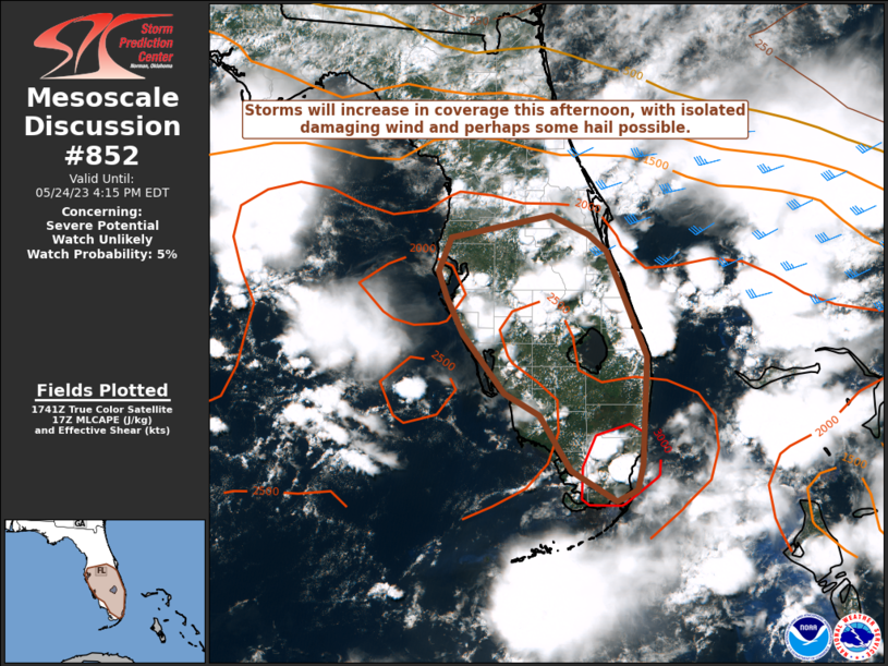
NWS Storm Prediction Center Norman OK
1248 PM CDT Wed May 24 2023
Areas affected...Parts of central/south FL
Concerning...Severe potential...Watch unlikely
Valid 241748Z - 242015Z
Probability of Watch Issuance...5 percent
SUMMARY...Storms will continue to increase in coverage this
afternoon, with localized damaging wind and perhaps some hail
possible. WW issuance is not expected.
DISCUSSION...Seasonably cool midlevel temperatures (around -11 C)
were noted on the 12Z TBW and MFL soundings this morning, in
association with a weak but rather broad upper-level trough
extending from parts of the Southeast into the central/eastern Gulf
of Mexico. Robust diurnal heating beneath these cool temperatures
aloft will result in moderate to locally strong buoyancy (MLCAPE of
1500-3000 J/kg, greater with southward extent) with minimal MLCINH,
and storm coverage will continue to increase through the afternoon.
The primary foci for storm initiation will likely be sea breezes and
a weak cold front across the central peninsula. With generally weak
low-level flow and only modest mid/upper-level flow, storms may tend
to be rather disorganized, though some brief uptick in organization
could occur with storm mergers and/or cells that remain rooted near
one of the boundaries across the area. Localized damaging wind gusts
will be possible with the strongest cells/clusters, with some hail
also possible given the cooler temperatures aloft and favorable
buoyancy. With the severe threat expected to generally be isolated
and somewhat disorganized, watch issuance is unlikely.
..Dean/Grams.. 05/24/2023
...Please see www.spc.noaa.gov for graphic product...
ATTN...WFO...MFL...MLB...KEY...TBW...
LAT...LON 28248261 28498132 28278083 28098060 26878010 25658015
25368023 25238049 25588107 26208147 26458191 27128245
27548266 27848277 28248261
|
|
Top/All Mesoscale Discussions/Forecast Products/Home
|
|


 @NWSSPC