|
| Mesoscale Discussion 9 |
|
< Previous MD Next MD >
|
|
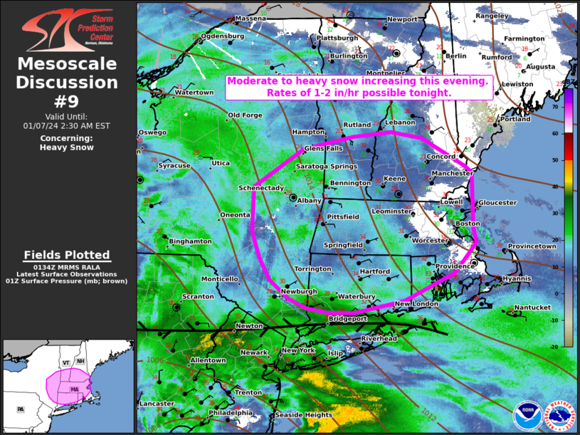
   Mesoscale Discussion 0009
   NWS Storm Prediction Center Norman OK
   0735 PM CST Sat Jan 06 2024

   Areas affected...portions of southern New England

   Concerning...Heavy snow

   Valid 070135Z - 070730Z

   SUMMARY...Moderate to heavy snow will slowly increase in coverage
   across portions of southern New England this evening. Snowfall rates
   of 1-2 in/hr are possible within the heaviest band late this evening
   into the overnight hours.

   DISCUSSION...As of 0130 UTC, regional radar and surface analysis
   showed a broad area of stratiform precipitation ongoing across parts
   of the Mid Atlantic and southern New England. Associated with an
   approaching coastal low, periodic moderate to heavy snow/rain has
   been observed within this precipitation over the last several hours.
   Slow northeastward progression of the heaviest precip has been noted
   with the primary east-west oriented band stretching from
   east-central PA to Long Island Sound. Driven by strong low-level
   warm advection ahead of the deepening coastal low, moderate to heavy
   snow should slowly increase in coverage over portions of southern
   New England late this evening and into the overnight hours. Rates
   between 1 to 2 in/hour are possible within the primary band, though
   there remains some uncertainty on how quickly the heaviest snow will
   lift northward. Light snow has already been reported across parts of
   RI, MA and CT but, regional model soundings and observed ceilings
   above 4k feet suggest some low-level dry air remains in place.
   Inland moisture advection and the approach of the surface low should
   slowly cool and moisten the low-level thermodynamic profile
   sufficiently for higher snow rates after 03z. Periods of moderate to
   heavy snow will likely continue into the overnight hours.

   ..Lyons.. 01/07/2024

   ...Please see www.spc.noaa.gov for graphic product...

   ATTN...WFO...GYX...BOX...BTV...OKX...ALY...BGM...

   LAT...LON   41297318 41367356 41487386 41707418 41987436 42317449
               42887446 43367362 43527277 43587212 43497158 43137085
               43067073 42367073 42187068 41807105 41447191 41377230
               41297275 41297318
|
|
Top/All Mesoscale Discussions/Forecast Products/Home
|
|


 @NWSSPC