|
| Mesoscale Discussion 32 |
|
< Previous MD Next MD >
|
|
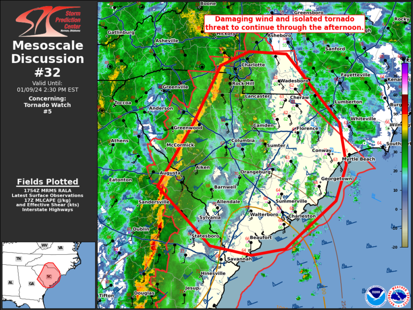
   Mesoscale Discussion 0032
   NWS Storm Prediction Center Norman OK
   1156 AM CST Tue Jan 09 2024

   Areas affected...central and eastern South Carolina and far southern
   North Carolina

   Concerning...Tornado Watch 5...

   Valid 091756Z - 091930Z

   The severe weather threat for Tornado Watch 5 continues.

   SUMMARY...A squall line capable of damaging wind gusts and isolated
   tornadoes is expected to continue through the afternoon.

   DISCUSSION...Ahead of a squall line in western South Carolina and
   eastern Georgia, instability remains weak, but sufficient for some
   damaging wind threat. Strong southeasterly 15-25 kt surface winds
   continue to advect significant low-level moisture northward which
   will further destabilize areas ahead of the line. Given the very
   strong wind profile (80 knots at 1km per CAE VWP), this line will
   likely continue to produce damaging winds, even with meager
   instability. In addition, strong shear with clockwise curved
   hodographs will support some QLCS tornado threat, particularly
   across southern South Carolina where mid-60s dewpoints have advected
   onshore.

   Additionally, a confluence band of showers has started to develop
   off the South Carolina coast. As cooler air aloft overspreads this
   region and low-level moisture continues to advect northward,
   instability is expected to increase and may lead to some potential
   for strong supercells and perhaps a greater threat for strong
   tornadoes given the greater instability and discrete mode.

   ..Bentley.. 01/09/2024

   ...Please see www.spc.noaa.gov for graphic product...

   ATTN...WFO...RAH...ILM...CHS...CAE...GSP...FFC...

   LAT...LON   34348174 35268122 35498066 35467993 34327889 33647877
               33077899 32297996 32198061 32348140 33298242 34348174
|
|
Top/All Mesoscale Discussions/Forecast Products/Home
|
|


 @NWSSPC