|
| Mesoscale Discussion 61 |
|
< Previous MD Next MD >
|
|
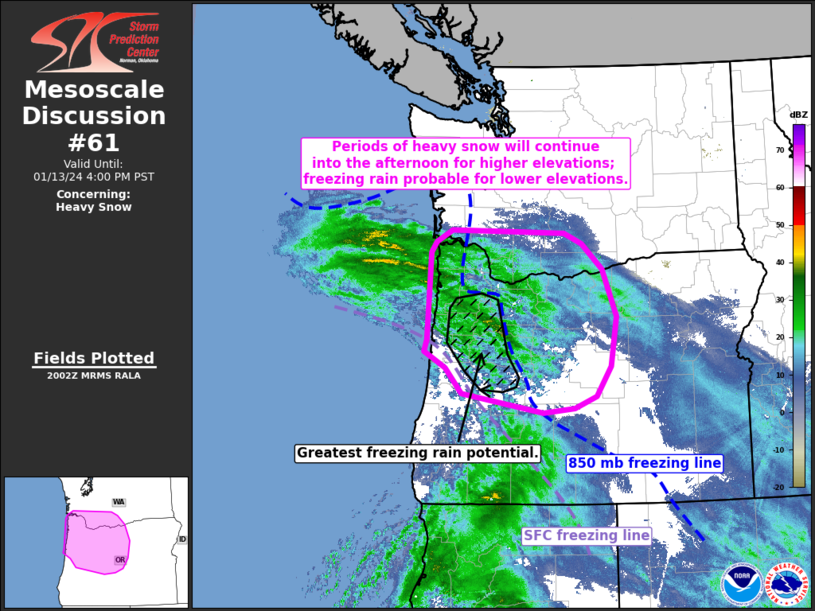
   Mesoscale Discussion 0061
   NWS Storm Prediction Center Norman OK
   0205 PM CST Sat Jan 13 2024

   Areas affected...Northwestern Oregon and far southeastern Washington

   Concerning...Heavy snow

   Valid 132005Z - 140000Z

   SUMMARY...Periods of heavy snow with snowfall rates between 1-2
   in/hour will continue into the mid/late afternoon hours. Freezing
   rain remains probable through the Willamette Valley.

   DISCUSSION...Bands of moderate to heavy precipitation continue to
   overspread the Pacific Northwest ahead of an approaching mid-level
   wave. So far, much of this activity has been driven by warm
   advection in the 850-700 mb layer, but some uptick in precip
   coverage and intensity appears likely as lift associated with the
   vorticity maximum and attendant mid-level jet overspreads the
   region. The 18z SLE sounding sampled a deep saturated layer from the
   surface to around 450 mb with a somewhat shallow (~100 mb deep) 1-2
   C warm nose centered at about 850 mb/3 kft. More recent KRTX CC
   imagery indicates that this warm nose remains in place. Locations
   above roughly 3 kft should continue to see moderate to heavy
   snowfall through the mid/late afternoon with snowfall rates between
   1-2 in/hour possible. The shallow sub-freezing layer below ~3 kft
   will support a continuation of freezing rain for some locations -
   primarily through the Willamette Valley. However, localized
   fluctuations in the shallow warm layer may promote variation in
   precipitation types between freezing rain, snow, and sleet.

   ..Moore.. 01/13/2024

   ...Please see www.spc.noaa.gov for graphic product...

   ATTN...WFO...PDT...MFR...SEW...PQR...

   LAT...LON   44192375 44442423 44642418 46032410 46212399 46392363
               46352107 46182067 45762021 45001991 44212004 43732038
               43532087 43462157 43772338 44192375
|
|
Top/All Mesoscale Discussions/Forecast Products/Home
|
|


 @NWSSPC