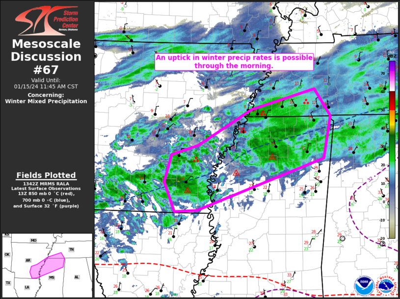
   Mesoscale Discussion 0067
   NWS Storm Prediction Center Norman OK
   0745 AM CST Mon Jan 15 2024

   Areas affected...ArkLaTex into parts of the Mid South/TN Valley

   Concerning...Winter mixed precipitation

   Valid 151345Z - 151745Z

   SUMMARY...An uptick in winter precipitation rates is possible
   through the morning. Moderate snow will be possible along the
   northern part of the precipitation shield, with sleet and localized
   freezing rain to the south.

   DISCUSSION...Some increase in coverage and intensity of winter
   precipitation has been noted on radar over the last 1-2 hours
   near/east of the ArkLaTex region, likely in response to an
   approaching mid/upper-level shortwave trough moving across the
   southern Plains. This area of precipitation will move
   east-northeastward toward the Mid South region, with downstream
   enhancement of precipitation possible later this morning toward the
   TN Valley region, within a persistent warm-advection regime.

   12Z soundings from SHV and JAN depicted a notable warm layer from
   900-750 mb, with LZK sounding also briefly rising above freezing
   around 750 mb. Dual pol data from KNQA indicate that the sleet/snow
   transition line runs roughly east-west, just to the south of the
   TN/MS border. There may be some tendency for the sleet/snow line to
   move slightly southward with time across northern MS, as ascent
   attendant to the approaching shortwave results in some midlevel
   cooling, while low-level warm advection gradually abates. However,
   some oscillations in precipitation type will continue to be possible
   near the transition zone.

   Where precipitation remains as or transitions to snow, moderate to
   briefly heavy precipitation rates may support localized rates near 1
   inch/hour. Otherwise, occasionally moderate sleet will accompany the
   heavier precipitation, with freezing rain remaining possible along
   the southern fringe of the precipitation shield.

   ..Dean.. 01/15/2024

   ...Please see www.spc.noaa.gov for graphic product...

   ATTN...WFO...HUN...MEG...JAN...LZK...

   LAT...LON   33069147 33029201 33639227 34209210 34409144 35149013
               35558857 34998818 34138835 33069147
|


 @NWSSPC