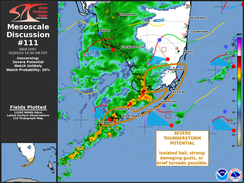
   Mesoscale Discussion 0111
   NWS Storm Prediction Center Norman OK
   0730 AM CST Mon Feb 05 2024

   Areas affected...Portions of the FL Keys and extreme southern
   mainland FL.

   Concerning...Severe potential...Watch unlikely

   Valid 051330Z - 051530Z

   Probability of Watch Issuance...20 percent

   SUMMARY...Isolated strong/damaging gusts, hail near severe limits,
   and conditional/brief tornado potential may occur with a band of
   thunderstorms moving up the Keys and brushing the southernmost
   mainland.

   DISCUSSION...At 1315Z, the primary band of thunderstorms extended
   from EYW to Cape Sable, along and south of an outflow boundary from
   earlier convection that was analyzed over northern portions of FL
   Bay and eastward across the Straits just southeast of HST.  This
   activity occasionally has had an embedded supercell over open water,
   and has produced several reports of small hail, as well as
   strong/subsevere gusts around Key West (42 kt at EYW and 41 kt at
   NQX).  While the predominant mode should remain quasi-linear, an
   additional/isolated supercell or bowing segment may develop within
   the band as it proceeds eastward over the remainder of FL Bay, the
   middle/upper Keys, and southern Miami-Dade County.

   The outflow boundary should drift northward amid modest ambient flow
   (generally 5-10-kt surface winds), but also, may maximize low-level
   shear/vorticity locally.  The air mass to its north remains
   unfavorable, per modified 12Z MFL RAOB, but the modified/proximity
   KEY sounding showed a layer of steep low/middle-level lapse rates
   and greater moisture content that has supported the activity then
   not far to its north through southwest.  Veering of flow just above
   the surface limits hodograph size somewhat; however, 100-200 J/kg
   effective SRH and 40-50-kt effective-shear magnitudes still have
   been evident along and south of the boundary.

   ..Edwards.. 02/05/2024

   ...Please see www.spc.noaa.gov for graphic product...

   ATTN...WFO...MFL...KEY...

   LAT...LON   25488086 25598029 25518013 25058039 24738093 24568151
               24558170 24738163 24848143 24848121 24788110 24898084
               25028060 25188049 25118068 25168090 25488086
|


 @NWSSPC