|
| Mesoscale Discussion 115 |
|
< Previous MD Next MD >
|
|
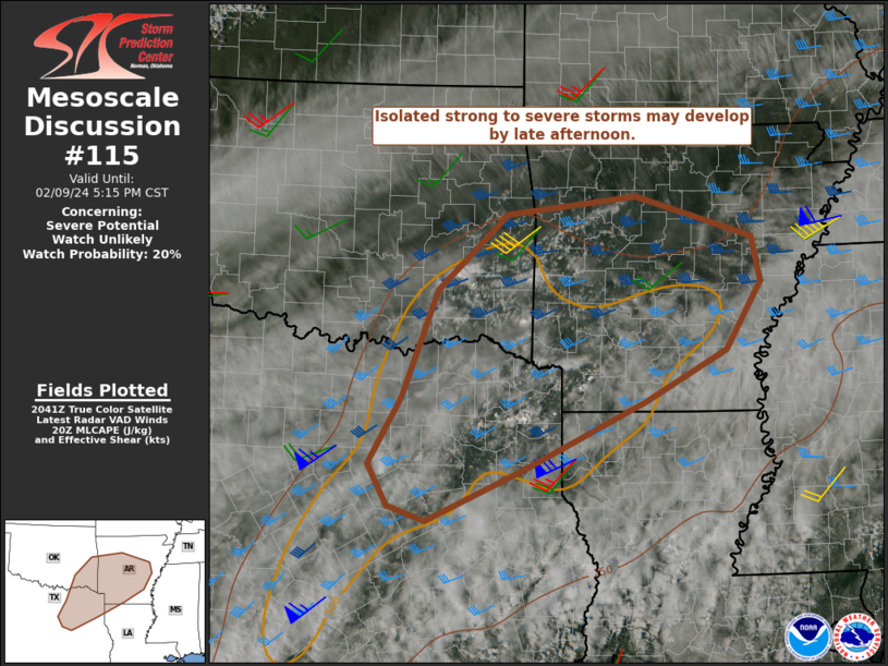
   Mesoscale Discussion 0115
   NWS Storm Prediction Center Norman OK
   0249 PM CST Fri Feb 09 2024

   Areas affected...Parts of northeast TX...southeast
   OK...central/southern AR...Far northwest LA

   Concerning...Severe potential...Watch unlikely

   Valid 092049Z - 092315Z

   Probability of Watch Issuance...20 percent

   SUMMARY...Isolated strong to severe storms may develop by late
   afternoon. Hail will likely be the primary threat with these storms,
   but locally damaging gusts and/or a brief tornado cannot be ruled
   out.

   DISCUSSION...A cumulus field is gradually deepening across parts of
   the ArkLaTex region this afternoon, beneath an extensive cirrus
   shield emanating from the subtropical Pacific. A few lightning
   flashes have been noted with a developing cell across far northeast
   TX, with other attempts at convective initiation noted on regional
   radar. Large-scale ascent is likely to remain subtle at best over
   the next several hours within broad southwesterly flow aloft, but
   continued filtered heating of a moist and weakly capped environment
   may support widely scattered thunderstorm development by late
   afternoon.

   Cold temperatures aloft (-16C to -18C at 500 mb) atop a relatively
   moist boundary layer are supporting favorable buoyancy through
   midlevels, though a notable temperature inversion near the base of
   the subtropical jet near 400 mb will limit CAPE magnitudes (with
   MLCAPE generally 500-1000 J/kg) and truncate updraft depths. Despite
   the relatively low-topped nature of convection, effective shear of
   35-45 kt may support some storm organization, and a few stronger
   multicells and/or a marginal supercell or two could evolve with
   time. Isolated instances of large hail would likely be the primary
   initial threat with any organized storm, though isolated strong
   gusts cannot be ruled out. A gradual increase in low-level shear/SRH
   is expected from late afternoon into early evening, and could
   support a brief tornado threat if a supercell can be sustained.

   With the threat currently expected to be isolated and relatively
   limited in magnitude, watch issuance is considered unlikely.

   ..Dean/Thompson.. 02/09/2024

   ...Please see www.spc.noaa.gov for graphic product...

   ATTN...WFO...LZK...SHV...TSA...FWD...OUN...

   LAT...LON   32299463 31669601 31859656 32359685 33179638 34509586
               35439483 35649294 35149122 34599110 33759163 33139281
               32609394 32299463
|
|
Top/All Mesoscale Discussions/Forecast Products/Home
|
|


 @NWSSPC