|
| Mesoscale Discussion 121 |
|
< Previous MD Next MD >
|
|
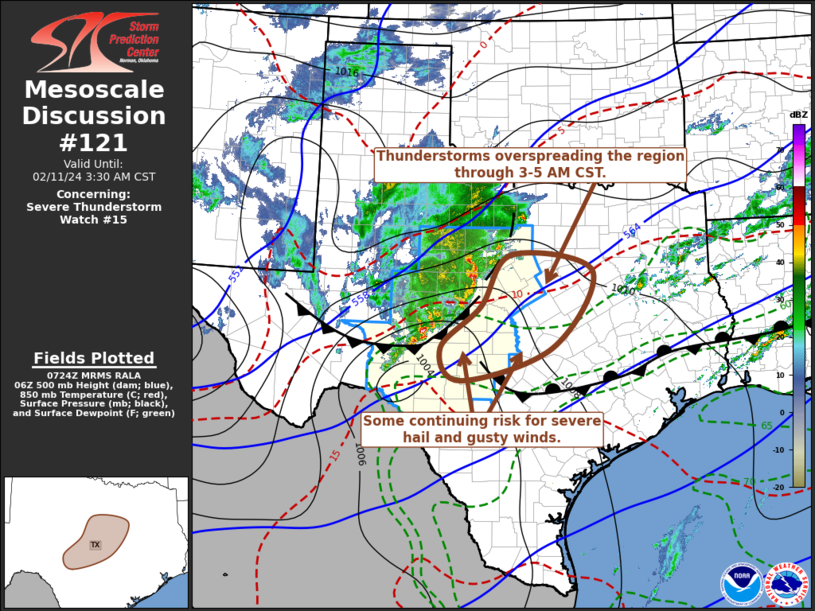
   Mesoscale Discussion 0121
   NWS Storm Prediction Center Norman OK
   0126 AM CST Sun Feb 11 2024

   Areas affected...central Texas

   Concerning...Severe Thunderstorm Watch 15...

   Valid 110726Z - 110930Z

   The severe weather threat for Severe Thunderstorm Watch 15
   continues.

   SUMMARY...A cluster of thunderstorms will continue to spread
   east-northeastward toward the Interstate 35 corridor of north
   central and central Texas through 3-5 AM CST.  This activity may
   continue to pose some risk for severe hail and gusty winds, mainly
   near/north of the Junction through Austin vicinities.

   DISCUSSION...Stronger flow around the 500 mb level is still nosing
   into areas near/north of the Texas Big Bend.  But a more modest
   preceding speed maximum, which likely has provided support for the
   evolving ongoing cluster of storms, is forecast to continue
   propagating north-northeastward across central Texas through 09-11Z.


   The associated convection likely will remain rooted within lift
   associated with lower/mid-tropospheric warm advection, above cold
   surface-based air now nosing south-southeast of the Texas South
   Plains.  North of the Junction/Kerrville/Austin/College Station
   vicinities, a more modestly cool and stable near-surface layer is
   not likely to modify much in advance of the convection.  However,
   elevated instability and cloud-bearing layer shear may remain
   sufficient to continue supporting some risk for severe hail and
   gusty winds, particularly near the southern flank of the convective
   system passing near/north of the Junction and Austin vicinities.
   Farther south, where mid/upper forcing for ascent becomes more
   negligible, warmer and more strongly capping mid-level air is
   forecast to inhibit convective development.

   ..Kerr.. 02/11/2024

   ...Please see www.spc.noaa.gov for graphic product...

   ATTN...WFO...FWD...EWX...SJT...

   LAT...LON   31429922 32429854 32119668 30629761 29989967 30610013
               31429922
|
|
Top/All Mesoscale Discussions/Forecast Products/Home
|
|


 @NWSSPC