|
| Mesoscale Discussion 218 |
|
< Previous MD Next MD >
|
|
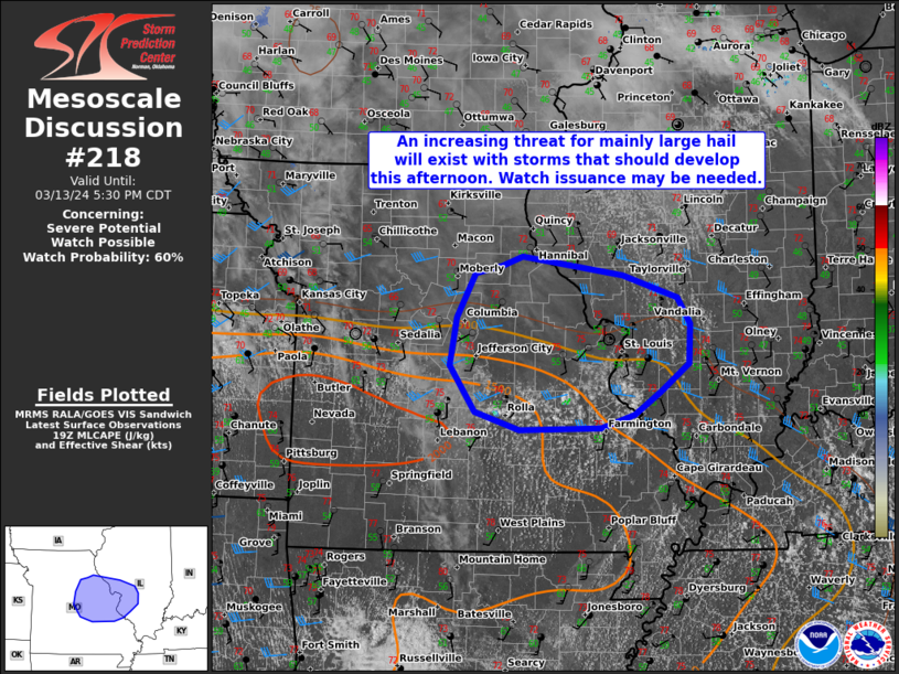
   Mesoscale Discussion 0218
   NWS Storm Prediction Center Norman OK
   0256 PM CDT Wed Mar 13 2024

   Areas affected...Portions of east-central MO and west-central IL

   Concerning...Severe potential...Watch possible

   Valid 131956Z - 132230Z

   Probability of Watch Issuance...60 percent

   SUMMARY...An increasing threat for mainly large hail will exist with
   storms that should develop this afternoon. Watch issuance may be
   needed.

   DISCUSSION...Low-level moisture continues to advect northward along
   a warm front across central/eastern MO, with surface dewpoints
   generally increasing into the mid to upper 50s F. Recent visible
   satellite imagery shows a cu field gradually deepening and becoming
   more agitated over east-central MO in tandem with this returning
   moisture. Eventual thunderstorm development seems probable by 21-22Z
   (4-5 PM CDT) as parcels reach their convective temperature amid an
   uncapped and moderately unstable airmass. The presence of around
   1000-1500 J/kg of MLCAPE, with moderately steepened mid-level lapse
   rates, will likely encourage robust updrafts. Although low/mid-level
   flow remains fairly modest at the moment, sufficient deep-layer
   shear of 30-35 kt should support updraft organization/rotation and
   some supercell potential. The main severe risk appears to be large
   hail with any thunderstorms that can develop and be sustained this
   afternoon and early evening. But, some threat for strong to locally
   damaging winds may also exist. Depending on convective trends, watch
   issuance may be needed this afternoon.

   ..Gleason/Guyer.. 03/13/2024

   ...Please see www.spc.noaa.gov for graphic product...

   ATTN...WFO...LSX...SGF...

   LAT...LON   37789157 37979217 38479251 38979242 39449217 39539181
               39629153 39439018 39198943 38908926 38498929 38198967
               37959003 37819047 37789157
|
|
Top/All Mesoscale Discussions/Forecast Products/Home
|
|


 @NWSSPC