|
| Mesoscale Discussion 225 |
|
< Previous MD Next MD >
|
|
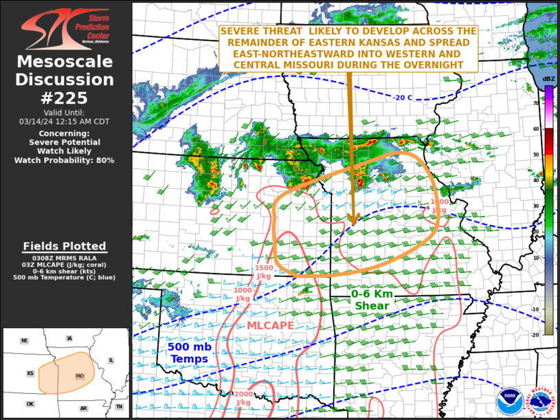
   Mesoscale Discussion 0225
   NWS Storm Prediction Center Norman OK
   1010 PM CDT Wed Mar 13 2024

   Areas affected...Eastern Kansas...Western and Central Missouri

   Concerning...Severe potential...Watch likely

   Valid 140310Z - 140515Z

   Probability of Watch Issuance...80 percent

   SUMMARY...A severe threat is expected to develop across the
   remainder of eastern Kansas around midnight. The storms are forecast
   to spread east-northeastward into Missouri during the early
   overnight period. Weather watch issuance will likely be needed
   across the region within the next 90 minutes.

   DISCUSSION...The latest water vapor imagery shows an upper-level
   trough over the Desert Southwest, with a mid-level jet in the base
   of the system extending east-northeastward into the southern Plains
   and northern Ozarks. A distinct mid-level vorticity max is located
   over far southwest Kansas. This feature will move across the central
   Plains late this evening. As large-scale ascent increases ahead of
   the vorticity max, scattered strong thunderstorms are expected to
   develop across south-central Kansas, and move east-northeastward
   across eastern Kansas and Missouri. According to the RAP, MLCAPE
   within this area is between 1000 and 1500 J/kg, 0-6 km shear is in
   the 40 to 50 knot range, and 700-500 mb lapse rates are from 7.5 to
   8 C/km. This should support a severe threat overnight, especially
   the stronger cells interact with the low-level jet. Supercells with
   large hail appear likely, and wind damage will also be possible.

   ..Broyles/Hart.. 03/14/2024

   ...Please see www.spc.noaa.gov for graphic product...

   ATTN...WFO...LSX...SGF...EAX...TOP...ICT...

   LAT...LON   37899643 38439646 39129617 40039316 40209236 40029169
               39339119 38329112 37779177 37279309 37059441 37019556
               37059581 37329634 37899643
|
|
Top/All Mesoscale Discussions/Forecast Products/Home
|
|


 @NWSSPC