|
| Mesoscale Discussion 259 |
|
< Previous MD Next MD >
|
|
Mesoscale Discussion 0259
NWS Storm Prediction Center Norman OK
1228 PM CDT Fri Mar 15 2024
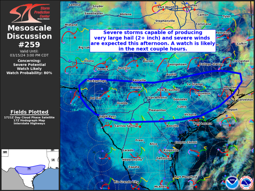
Areas affected...Portions of south-central and southeast Texas
Concerning...Severe potential...Watch likely
Valid 151728Z - 152000Z
Probability of Watch Issuance...80 percent
SUMMARY...Severe storms capable of producing very large hail (2+
inch) and severe winds are expected across portions of south-central
and southeast Texas this afternoon. A watch will likely be issued in
the next couple hours for parts of the area.
DISCUSSION...Latest surface observations and visible satellite
imagery indicate an east/west-oriented outflow-modified cold front
gradually stalling across parts of south-central into southeast TX
this afternoon. Given that much of this area is on the backside of a
departing shortwave trough moving east-northeastward across east TX,
overall coverage of storms is a bit uncertain. Nevertheless, as the
frontal circulation intersects a gradually deepening moist layer
amid pockets of diurnal heating, at least isolated to widely
scattered storm development is expected this afternoon -- possibly
aided by weak low-level warm advection atop the frontal surface/cold
pool. An additional focus for storm development will be over the
southern portion of the Edwards Plateau, where the front intersect
the higher terrain amid upslope flow enhancements.
The latest ACARS soundings from San Antonio TX sampled steep
midlevel lapse rates (near 8 C/km) associated with an EML atop a
gradually deepening moist layer extending through 1 km AGL.
Continued diurnal heating of this moist layer should contribute to
moderate/strong instability (2500-3000 J/kg MLCAPE). In addition, a
belt of 40-50 kt midlevel west-southwesterly flow above veering
low-level flow will yield 40-50 kt effective shear. This will
support the development of initially semi-discrete supercell
clusters, capable of producing very large hail (some greater than
baseball-sized), along with locally severe winds. While a tornado or
two cannot be entirely ruled out with these storms, low-level shear
will not be particularly strong, and the development of strong cold
pools could reduce the risk to an extent. With time, localized
upscale growth into several organized clusters is possible, with an
increasing wind risk and continued large hail threat with
east-southeastward extent.
..Weinman/Goss.. 03/15/2024
...Please see www.spc.noaa.gov for graphic product...
ATTN...WFO...LCH...HGX...CRP...EWX...
LAT...LON 29110097 29450126 29890135 30100106 30140073 30049826
30169736 30359635 30449568 30439523 30329461 30039456
29589492 29139556 28829632 28699705 28639790 28609943
28720015 28860062 29110097
|
|
Top/All Mesoscale Discussions/Forecast Products/Home
|
|


 @NWSSPC