|
| Mesoscale Discussion 330 |
|
< Previous MD Next MD >
|
|
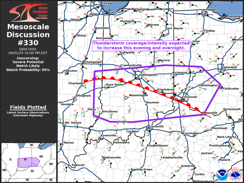
   Mesoscale Discussion 0330
   NWS Storm Prediction Center Norman OK
   0737 PM CDT Mon Apr 01 2024

   Areas affected...southern Indiana into southwest Ohio

   Concerning...Severe potential...Watch likely

   Valid 020037Z - 020200Z

   Probability of Watch Issuance...95 percent

   SUMMARY...Thunderstorm coverage and intensity is expected to
   increase this evening and overnight with a primary threat for large
   hail and damaging wind gusts.

   DISCUSSION...Thunderstorm coverage is increasing across central
   Illinois with these storms eventually moving into Indiana later this
   evening. Additional development is likely farther east into Indiana
   and Ohio. Most of these storms will likely remain north of the warm
   front where storms will predominantly be elevated with a threat for
   large hail and isolated wind gusts. The 00Z ILN RAOB shows shear
   which will support supercells and a threat for large hail and
   potentially some very large hail.

   Initially the tornado threat should remain limited given the
   majority of storms should be north of the warm front. However, after
   midnight, storms are expected to develop/move into areas south of
   the warm front where the tornado threat will be greater. A severe
   thunderstorm watch will be issued for the initial threat and trends
   will be monitored if a tornado watch is needed for the activity
   later tonight.

   ..Bentley/Hart.. 04/02/2024

   ...Please see www.spc.noaa.gov for graphic product...

   ATTN...WFO...ILN...LMK...IND...PAH...ILX...

   LAT...LON   39918783 40118513 40058376 39528304 38658371 38588474
               38438637 38438719 38628782 39918783
|
|
Top/All Mesoscale Discussions/Forecast Products/Home
|
|


 @NWSSPC