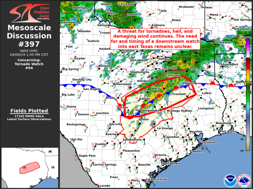
   Mesoscale Discussion 0397
   NWS Storm Prediction Center Norman OK
   1212 PM CDT Tue Apr 09 2024

   Areas affected...Portions of central TX

   Concerning...Tornado Watch 94...

   Valid 091712Z - 091845Z

   The severe weather threat for Tornado Watch 94 continues.

   SUMMARY...A threat for tornadoes, hail, and damaging winds
   continues. The need for and timing of a downstream watch into east
   Texas remains unclear.

   DISCUSSION...Thunderstorms have remain focused along/very near the
   convectively reinforced outflow boundary that is draped southwest to
   northeast across central TX. Mergers/interactions between various
   thunderstorms have led to an overall messy convective mode. Even so,
   the environment remains conditionally favorable for severe
   convection, including supercells, given adequate instability and
   ample deep-layer shear. In the short term, the tornado threat will
   continue to be supported by a 30-40 kt south-southwesterly low-level
   jet providing generally 200-300 m2/s2 of effective SRH. But, the
   best chance for tornadoes will probably occur with any supercell
   that can develop/persist on the southern flank of the ongoing
   convection. Similarly, the hail threat will be tied to a supercell
   being able to remain at least semi-discrete, which remains
   questionable given the ongoing thunderstorm evolution.
   Severe/damaging wind potential may increase through the early
   afternoon if a cluster can consolidate and spread eastward. The need
   for and timing of a downstream watch into east TX remains uncertain,
   as widespread cloud cover is slowing airmass recovery along/near the
   surface boundary in the wake of earlier convection.

   ..Gleason.. 04/09/2024

   ...Please see www.spc.noaa.gov for graphic product...

   ATTN...WFO...SHV...HGX...FWD...EWX...

   LAT...LON   31279834 31919685 32159564 31969524 31389498 30839633
               30489768 30449836 31019839 31279834
|


 @NWSSPC