|
| Mesoscale Discussion 415 |
|
< Previous MD Next MD >
|
|
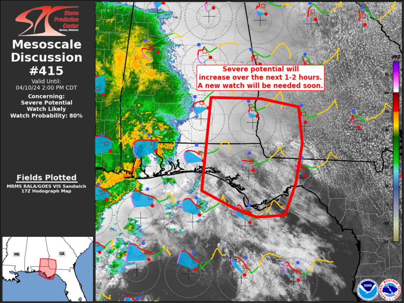
   Mesoscale Discussion 0415
   NWS Storm Prediction Center Norman OK
   1235 PM CDT Wed Apr 10 2024

   Areas affected...southeast Alabama...southwest Georgia and the
   Florida Panhandle

   Concerning...Severe potential...Watch likely

   Valid 101735Z - 101900Z

   Probability of Watch Issuance...80 percent

   SUMMARY...Severe potential is expected to increase from the Florida
   Panhandle northward across far southeast Alabama into southwest
   Georgia this afternoon. Damaging gusts and tornadoes will be
   possible as convection develops/spreads east into these areas.

   DISCUSSION...Stronger surface heating is noted across the MCD area
   amid diffuse upper clouds and increasing midlevel clouds. While
   boundary-layer dewpoints are modest in the low to mid 60s F, some
   minor increases in moisture also are possible over the next few
   hours. This should result in modest destabilization amid strong
   deep-layer shear as the bow echo currently near Mobile Bay continues
   to shift east this afternoon. With time, low-level shear is expected
   to increase. This will result in more favorable/enlarged low-level
   hodographs supporting tornadoes, in addition to damaging wind
   potential, both along the apex of the bow and with any cells ahead
   of/merging into the bow. A tornado watch will likely be needed
   within the hour across portions of the MCD area.

   ..Leitman/Guyer.. 04/10/2024

   ...Please see www.spc.noaa.gov for graphic product...

   ATTN...WFO...FFC...TAE...BMX...MOB...

   LAT...LON   31978622 31948499 31778405 30998397 30168415 29498442
               29458510 29648564 29998643 31978622
|
|
Top/All Mesoscale Discussions/Forecast Products/Home
|
|


 @NWSSPC