|
| Mesoscale Discussion 437 |
|
< Previous MD Next MD >
|
|
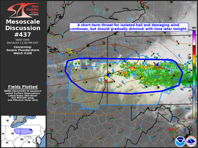
   Mesoscale Discussion 0437
   NWS Storm Prediction Center Norman OK
   0834 PM CDT Sun Apr 14 2024

   Areas affected...Part of eastern OH...western/central PA...northern
   WV Panhandle

   Concerning...Severe Thunderstorm Watch 108...

   Valid 150134Z - 150300Z

   The severe weather threat for Severe Thunderstorm Watch 108
   continues.

   SUMMARY...A threat for isolated hail and damaging wind continues,
   but should gradually diminish with time later tonight.

   DISCUSSION...A persistent storm cluster continues to backbuild
   across far eastern OH into western PA this evening, aided by a feed
   of modest low-level moisture beneath steep midlevel lapse rates (as
   noted on regional 00Z soundings). Deep-layer flow/shear remains
   sufficient for organized convection, and a couple of transient
   supercells have been noted this evening within the broader storm
   cluster. Large hail will continue to be a threat with the stronger
   cells near the western edge of the storm cluster, where a somewhat
   more discrete mode can be maintained. Rather strong low-level flow
   within a remnant well-mixed boundary layer will also continue to
   support a threat of isolated damaging gusts.

   With time, nocturnal cooling/stabilization will result in storms
   becoming increasingly elevated, with continued convection tending to
   deplete remaining MUCAPE (as has already occurred farther east).
   However, in the short term, some severe threat will spread
   southeastward in conjunction with the primary outflow boundary.
   Continued redevelopment of convection is also possible into
   northeast OH, where steep midlevel lapse rates could support an
   isolated hail threat into late evening.

   ..Dean.. 04/15/2024

   ...Please see www.spc.noaa.gov for graphic product...

   ATTN...WFO...CTP...PBZ...CLE...

   LAT...LON   40288172 40488206 40828236 41138228 41168222 41258177
               41268071 41207770 41117753 40767724 40357743 40177818
               40087948 40158143 40288172
|
|
Top/All Mesoscale Discussions/Forecast Products/Home
|
|


 @NWSSPC