|
| Mesoscale Discussion 439 |
|
< Previous MD Next MD >
|
|
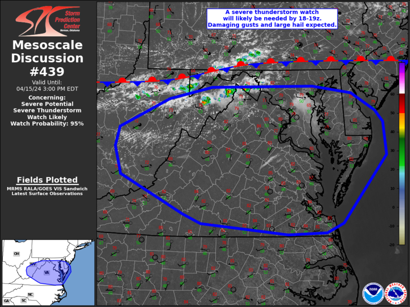
   Mesoscale Discussion 0439
   NWS Storm Prediction Center Norman OK
   1203 PM CDT Mon Apr 15 2024

   Areas affected...portions of West
   Virginia...Virginia...Maryland...and Delaware

   Concerning...Severe potential...Severe Thunderstorm Watch likely

   Valid 151703Z - 151900Z

   Probability of Watch Issuance...95 percent

   SUMMARY...Thunderstorm activity is expected to increase by 3-4pm
   EDT. Damaging gusts to 60-70 mph and large hail to 1.5 inches in
   diameter will be possible through early evening.

   DISCUSSION...Gradual destabilization is occurring from west to east
   early this afternoon across the MCD region. Increasing cumulus
   development is noted over the past hour across the higher terrain of
   West Virginia into northern Virginia as temperatures have warmed
   into the 70s to low 80s. The 12z MPAS-HT high-res guidance appears
   to have the best handle on morning convection across the region, and
   in the expected convective evolution through early evening. Based on
   this guidance, and current observed trends, thunderstorm activity is
   expected to increase by 19-20z/3-4pm EDT near/south of a residual
   frontal boundary draped west to east across the region. This
   development will be aided by continued heating/destabilization,
   increasing midlevel moisture and a very steep low and midlevel lapse
   rate environment (midlevel lapse rates around 8 C/km with southward
   extent across VA).

   While low-level winds will remain light, a belt of 30-40 kt midlevel
   flow will foster effective shear magnitudes suitable for organized
   convection. Initial cellular activity will pose a risk for large
   hail and strong gusts. Meanwhile, a deeply mixed boundary-layer with
   inverted-v sub-cloud thermodynamic profiles suggest strong outflow
   winds will occur with this activity and clustering is likely to
   occur via outflow interactions. A damaging wind threat will increase
   with southeastward extent across Virginia toward the Chesapeake Bay
   vicinity where steep low-level lapse rates and DCAPE over 1000 J/kg
   will be focused.

   A severe thunderstorm watch will likely be needed for portions of
   the MCD vicinity by 18-19z.

   ..Leitman/Smith.. 04/15/2024

   ...Please see www.spc.noaa.gov for graphic product...

   ATTN...WFO...PHI...AKQ...LWX...RNK...PBZ...RLX...

   LAT...LON   39387892 39417647 39277553 38927496 38717477 38077471
               36797576 36617617 36577708 36797916 36977959 37708109
               38248124 38618114 38868058 39157996 39387892
|
|
Top/All Mesoscale Discussions/Forecast Products/Home
|
|


 @NWSSPC