|
| Mesoscale Discussion 485 |
|
< Previous MD Next MD >
|
|
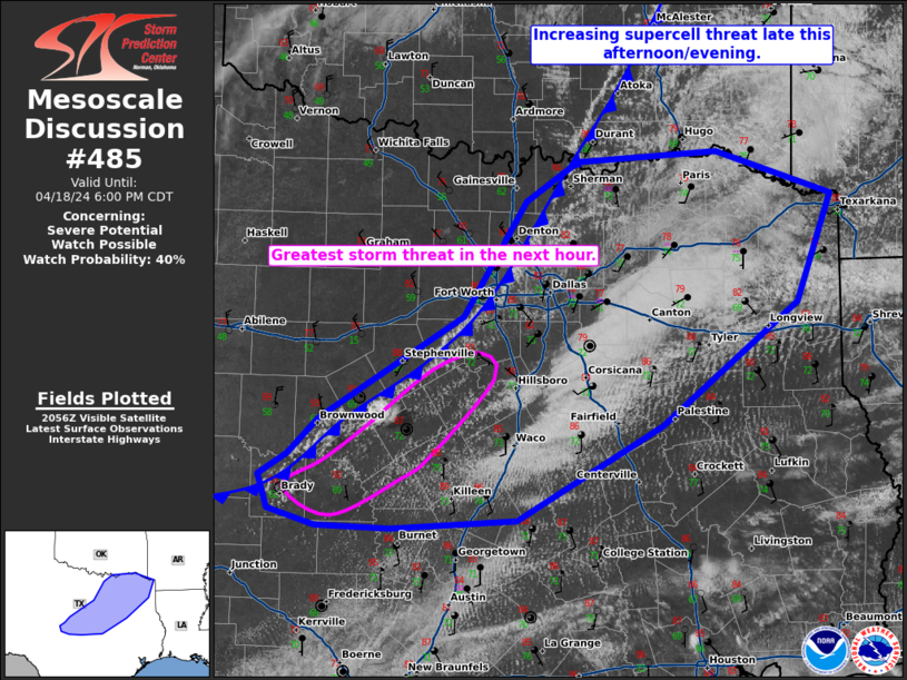
   Mesoscale Discussion 0485
   NWS Storm Prediction Center Norman OK
   0402 PM CDT Thu Apr 18 2024

   Areas affected...central/north-central into northeast Texas

   Concerning...Severe potential...Watch possible

   Valid 182102Z - 182300Z

   Probability of Watch Issuance...40 percent

   SUMMARY...The threat for isolated to widely scattered supercells
   will increase late this afternoon into the early evening.

   DISCUSSION...A very unstable airmass has developed across central
   and northeast Texas with low to mid 70s dewpoints and temperatures
   in the 80s. MLCAPE around 3000 J/kg and effective shear around 25 to
   30 knots will support organized storms including the potential for
   supercells. However, storm coverage remains questionable due to
   relatively weak forcing. In the near term, the best potential for
   storm development is in central Texas where temperatures are hot
   (near 90 F) and convergence is greater. Visible satellite shows
   cumulus clustering in this region with at least one orphan anvil.

   A severe thunderstorm watch may be needed if mature thunderstorm
   development appears imminent. This region is south of the mid-level
   speed max which is resulting in less shear. However, shear should be
   sufficient for supercells, and given the extreme buoyancy, very
   large hail (up to baseball size) is possible.

   ..Bentley/Mosier.. 04/18/2024

   ...Please see www.spc.noaa.gov for graphic product...

   ATTN...WFO...SHV...TSA...FWD...OUN...EWX...SJT...

   LAT...LON   30879829 30889900 31019945 31289954 31459926 31749898
               32579761 33509702 33829654 33909521 33569412 32699445
               31699573 30939711 30879829
|
|
Top/All Mesoscale Discussions/Forecast Products/Home
|
|


 @NWSSPC